.
. YORKSHIRE AND HUMBER
| BRITAIN'S FAVOURITE WALKS TOP 100 ― Yorkshire and the Humber |
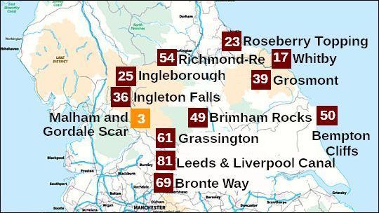
• Nummer 23 betekent: de wandeling eindigde op de 23ste plek in Britain's Favourite Walks: Top 100.
• Klik je op 23 (of de naam) in de kaart, dan word je doorverbonden met kader 23 hieronder.
• De wandelingen uit de Top 10 hebben een oranje nummer gekregen. Hier is dat nummer 3
Dat is dus een bijzonder fraaie wandeling.
• Lichtbruin = National Park
• Lichtgroen = AONB (Area of Outstanding Natural Beauty) (the next step down from a National Park).
• In de regio Yorkshire and the Humber heb je twee belangrijke nationale parken: het Yorkshire Dales National Park en het North York Moors National Park. (Op bovenstaande kaart zie je het Lake District National Park en de North Pennines AONB staan. Deze twee behoren echter niet tot de Yorkshire and the Humber regio.)
| aaaa |
3
3. Malham Cove & Gordale Scar
Yorkshire Dales National Park
12 km ..... middelzwaar
A beautiful countryside walk that’s full of surprises.
Malham Cove and Gordale Scar are two of the most spectacular
geological features in Britain.
This circular walk from the pretty village of Malham visits two geological wonders – Malham Cove and Gordale Scar – in one action-packed walk through the Yorkshire Dales National Park.
Malham Cove is a spectacular natural limestone formation which
comprises a curved limestone cliff at the head of a valley.
The limestone pavement at the top is a superb example of later
karst weathering.
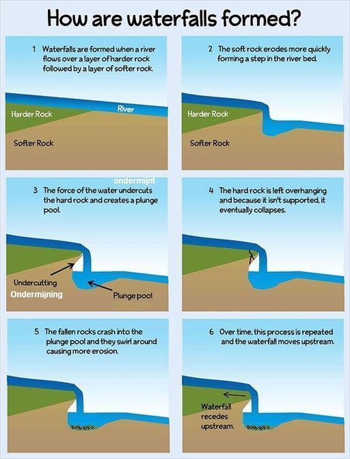
Malham Cove was once a mighty waterfall. A large waterfall flowed
over
the edge of the cove as the glacier melted and eroded the lip to
form a
curve.
Today underlying cave systems have a large enough
capacity to
swallow any water before it reaches the fall, and the stream now
disappears into a ‘sink’ about a mile from the edge.
The last record of
water flowing over the fall in
an appreciable volume
was in the early part of the 19th century.
The cliffs are popular with climbers and nesting peregrines (=slechtvalken) , with steep steps leading up the
Cove’s left flank to
the spectacular limestone pavement (kalksteenplaveisel) at the top
with its:
- clints = rectangular limestone blocks) and
- grikes ( fissures (spleten) between the rectangular blocks)
(Walk carefully, to avoid breaking ankles!)
...Limestone (Kalksteen) = Limestone pavement (kalksteenplaveisel) = Clints (blokken) = Grikes/Grykes) (spleten) = |
Zie verder de uitgebreide introductie over de Limestone uplands:
engeland_upland-limestone-landscapes
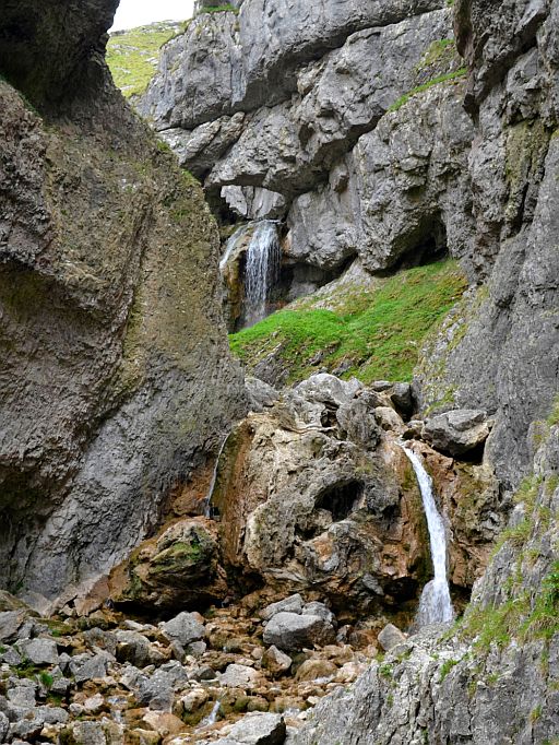
From the limestone pavement your route visits Malham Tarn before
heading south to the impressive ravine of Gordale Scar, with its steep
walls and stunning water cascades.
If you’re feeling brave you can scramble down to the base of the gorge,
where a beautiful riverside path leads through woodlands and past the
picture-perfect waterfall of Janet’s Foss back to Malham village.
IMPORTANT:
Take care if you decide to scramble up or down the waterfall at Gordale
Scar. The route is obvious and the handholds are good, but the rocks
can
be
slippery, particularly after periods of heavy rain.

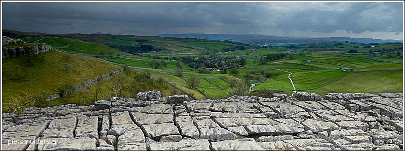
• Malham Cove is a cliff of 70 m high and 270 m wide.
• A large waterfall flowed over the edge of the cove as the glacier melted and eroded the. lip to form a curve.
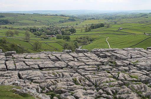
• Limestone pavement above Malham Cove.
• Grikes (= fissures, spleten) formed by the solvent action of rainwater on joints (=vertikale scheuren) in the limestone.
• Gordale Scar, a dramatic limestone gorge containing two waterfalls with overhanging limestone cliffs more than 300-feet high.
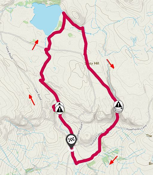
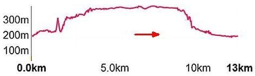
Totale stijging = 550 m
Hier heb je upland (= land lying above the limit of enclosed farmland).
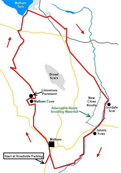
Start / finish:
At Roadside Parking in Malham.
Brochure Malham Trail:
Verkrijgbaar bij Malham National Park Cente.
ANWB Campings:
Zie voor een overzicht anwb.nl/engeland
Wildkamperen (bivak):
Gaf mij geen problemen.
Verdere info:
www.happyhiker.co.uk/MyWalks/
.....................................................
www.geolsoc.org.uk/GeositesMa
....................................................
https://osmaps.ordnancesurvey.c
... Wandelgids: Kaarten: OS Explorer OL2, OL41 Te bestellen bij: |
| aaaa |
17
17 Whitby ― Robin Hood's Bay
North York Moors National Park
11 km ..... middelzwaar
This walk explores the fascinating history of Yorkshire’s rugged coast
on
a 7-mile route between the famous fishing ports of Whitby and
Robin
Hood’s Bay.
Starting in the historic town of Whitby – where Captain Cook learned
his
trade, Bram Stoker found inspiration for his Dracula novel and
Vikings
once destroyed the town’s historic abbey – you’ll follow the Cleveland
Way National Trail south towards the fishing village Robin Hood’s Bay.
Your route follows the edge of towering cliffs that explode with the
sound of seabirds in spring and summer.
The walking isn’t technical but the undulating terrain will give your legs
a
good test before you arrive in the picturesque Robin Hood’s Bay.
Its steep cobbled streets were once the scene of a busy smuggling trade,
but are now packed with pubs, cafes, gift shops and an excellent
chippy!
There’s a regular bus route between Whitby and Robin Hood’s Bay so
the
walk can be done in either direction, and if you fancy really
stretching
your
legs you can continue down the coast to Ravenscar,
set high on a beautiful headland.
Belangrijk:
Whitby en Robin Hoods Bay zijn mooi, maar het kustpad daartussen is niet bijzonder.
Neem daarom liever wandeling 8 uit je wandelgidsje.
Dat voert van Whitby noordwaarts naar Staithes.
Dat is wel een echte topper.
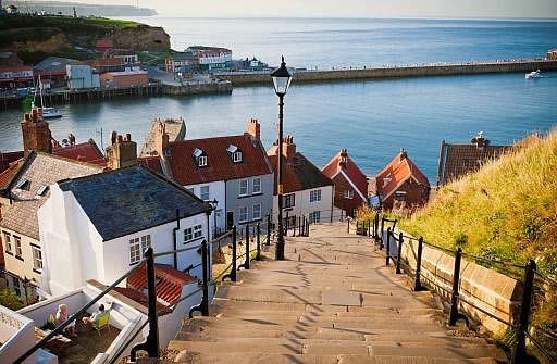
• Whitby is steeped in fishing and maritime history. It has the remains of a 13th-century abbey and was once a leading whaling port, as well as being the base fot Captain James Cook's historic 18th-century voyages to the New world.
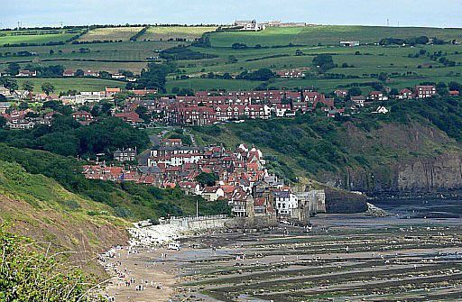
• Robin Hood's Bay clings to the steeply sloping hillside.
• Het is een schilderachtig dorpje met nauwe kronkelstraatjes.
• Bij eb zie je het indrukwekkende brandingsplatform.
• Daarop zijn een aantal
concentrische
cirkels van kleine
richels.
• Let ook op de grote keien die her en der liggen. Het zijn zwerfkeien meegevoerd door het landijs in
de laatste ijstijd. Ze komen helemaal uit het Lake district.
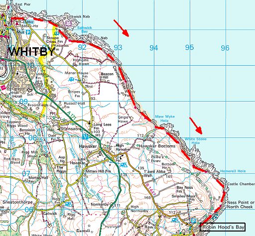
streetmap.co.uk
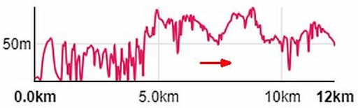
Totale stijging = 1420 m ?
Start: Whitby.
Finish:Robin Hood's Bay.
There is a coastal bus.
ANWB Campings:
Zie voor een overzicht anwb.nl/engeland
Wildkamperen (bivak):
Gaf mij geen problemen.
Zie voor een goede introductie van de verschillende kustvormen:
engeland_coastal-landscapes
Verdere info:
www.pietsmulders.nl/enge
...........................................
https://osmaps.ordnancesur
Wandelgids: ....... Kaart: OS Explorer OL27 Te bestellen bij: |
| aaaa |
23
23. Roseberry Topping
North York Moors National Park
10 km .... middelzwaar
Two famous landmarks for the price of one on a beautiful walk through ancient woodlands (=eeuwenoud bos) , across dramatic moorland and
up
to one of England’s finest summits.
This classic walk visits the iconic North York Moors landmarks of Captain Cook’s Monument and Roseberry Topping in one circular route.
Captain Cook’s Monument is a 60ft obelisk built in memory of the
legendary British explorer who was born in nearby Marton.
Roseberry Topping may be only 320 metres tall, but this sandstone
little
hill looks every inch a mountain.
Affectionately known as the Yorkshire Matterhorn, its rocky crown
and distinctive profile have fired the imagination of many aspiring
young mountaineers.
This beautiful walk starts in the pretty village of Great Ayton before
climbing the hillside to visit Captain Cook’s Monument.
From there you’ll follow the Cleveland Way over Great Ayton Moor before climbing to the summit of Roseberry Topping, then dropping
down through oak woodlands to your start point.
Eventueel:
Noord-Engeland (Rother Wandelgids) heeft een zeer korte wandeling naar Roseberry Topping vanuit Newton under Roseberry.
Mij spreekt de langere wandeling vanuit Great Ayton meer aan.
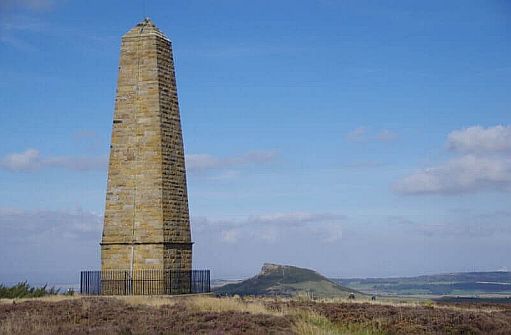
• Captain Cook’s Monument met rechts daarvan in de verte Roseberry Topping.
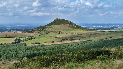
• Roseberry Topping with the well trodden path to the summit snaking its way up.
• Rechtsachter is Teeside-Middlesbrough. (Je staat ten zuidoosten van Roseberry Topping)
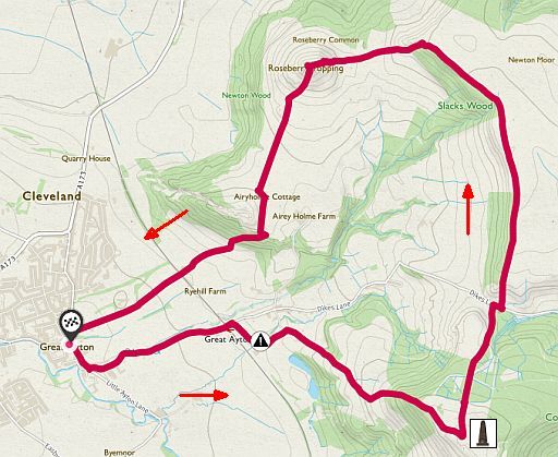
• Hier start je in het dorp Great Ayton.
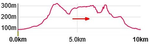
Totale stijging = 460 m
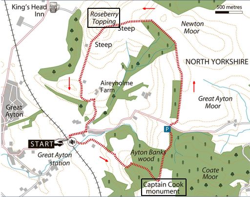
• Desgewenst start je bij het station van Great Ayton.
Start / finish:
Great Ayton or Great Ayton Station.
ANWB Campings:
Zie voor een overzicht anwb.nl/engeland
Wildkamperen (bivak):
Gaf mij geen problemen.
Verdere info:
www.pietsmulders.nl/eng
.........................................
https://osmaps.ordnancesu
Wandelgids: Kaart: OS Explorer OL 26 Te bestellen bij: |
| aaaa |
25
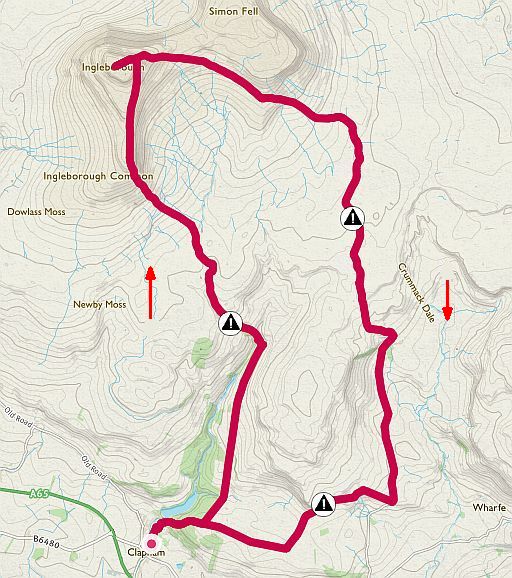
25. Ingleborough ( 724 m)
Yorkshire Dales National Park . mountain
18 km .......zwaar
The finest route up the finest hill in the Dales.
The ascent passes legendary caves and beautiful becks, with
stunning
360 views from the summit.
This rugged circular walk is a Yorkshire Dales classic, exploring Ingleborough’s most famous features on the way to its mighty summit.
With an altitude (= hoogte boven zeeniveau) of 724m Ingleborough is the second highest of the legendary Yorkshire Three Peaks, but it’s
by far the
most well known peak in the area.
This sprawling giant’s flanks are dotted with:
- limestone pavements (kalksteenplaveisels),
- gills/ghylls (rivierkloven) (ravines carved by a mountain stream),
- caves (grotten) , .......................................................................
- dolines, sinkholes (= A basin in limestone areas down which water disappears.).
- scars (kalksteenkliffen) , ..................................
This walk follows Clapham Beck to Trow Gill then passes the famous cave of Gaping Gill (ook wel Gaping Ghyll), one of the largest
underground
chambers in Britain.
You eventually climb to the summit via smaller the outlying peak of Little Ingleborough, then return via a different route that heads roughly
east from the top of Ingleborough on the Dales High Way before
sweeping south towards Clapham.
Described by legendary guidebook writer Alfred Wainwright as the
finest
of
all routes up Ingleborough, this is a must for hill walkers.
Zie vooraf ook de uitgebreide introductie over de Upland limestone landscapes:..engeland_upland-limestone-lan
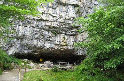
1. Entrance of Ingleborough Cave.
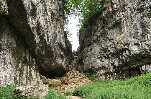
2. Walking up through Trow Gill, a dramatic limestone gorge.
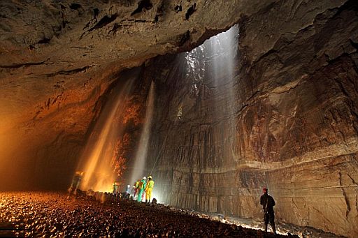
3. Fell Beck plunges 100m down into the limestone plateau creating Britain’s highest unbroken waterfall. It lands on the floor of Gaping Gill, the largest cave system in Britain.
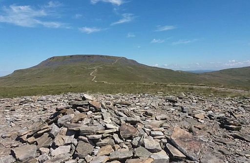
4. Ingleborough seen from Little Ingleborough.
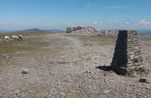
5. Ingleborough summit plateau with summit trig and shelter.
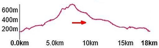
Totale stijging = 840 m
Boven op het plateau heb je upland
(=land lying above the limit of enclosed farmland).
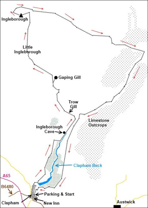
• Route volgens happyhiker.co.uk
Start / finish:
Clapham.
ANWB Campings:
Zie voor een overzicht anwb.nl/engeland
Wildkamperen (bivak):
Gaf mij geen problemen.
Zie voor een goede introducties van uplands:
engeland_uplands
Verdere info:
www.youtube.com/wat
......................................
https://osmaps.ordnance
....Wandelgids: Kaart: .OS Explorer OL2 Te bestellen bij: |
| aaaa |
36
36. Ingleton Waterfalls Trail
Yorkshire Dales National Park
7 km (3 - 4 uur)..... licht
One of the finest waterfall walks in Britain, but take some cash
because
it costs £6 for adults and £3 for children to access the trail.
The trail follows a well defined footpath with a large number of steps
along
the full route.
This 7 km circular walk from the Yorkshire Dales village of Ingleton visits
4 stunning waterfalls as you stroll through ancient woodlands.
The Ingleton Falls Trail follows a good footpath alongside two rivers that delivers glorious views of the waterfalls and many of the ancient
limestone
and slate base rocks that form the Yorkshire Dales National
Park.
You’ll pass Pecca Falls and Thornton Force on the River Twiss and Beezley Falls and Snow Falls on the River Doe, on a trail that was first developed in the 19th century for visitors arriving in Ingleton by train.
The unique geology of the area, plus its trees, plants and birdlife, have prompted Natural England to declare it a SSSI (= Site of Special
Scientific Interest ) .....
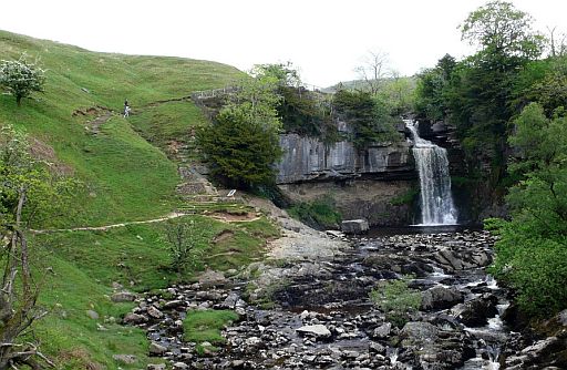
• Thornton Force plunges 46 feet into the River Twiss.
• It is the best of the many waterfalls found near Ingleton, on the edge of the Yorkshire Dales.
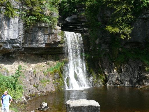
• Note the layer of limestone above the Ingleborough slates.
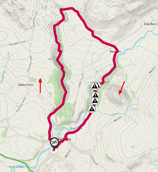
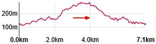
Totale stijging = 540 m
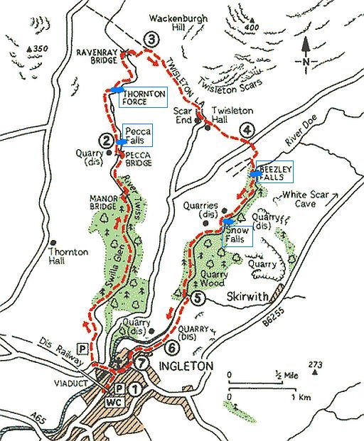
Start / finish:
Car Park in Ingleton
ANWB Campings:
Zie voor een overzicht anwb.nl/engeland
Wildkamperen (bivak):
Gaf mij geen problemen.
Verdere info:
www.ingletonwaterfallst
........................................
www.world-of-waterfalls.
(heeft ook fotogalerij en aantal video's)
https://osmaps.ordnances
...Wandelgids: Kaart: Te bestellen bij: |
| aaaa |
39
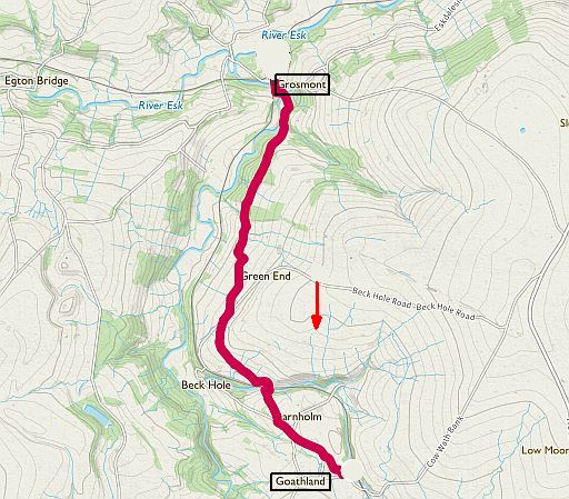
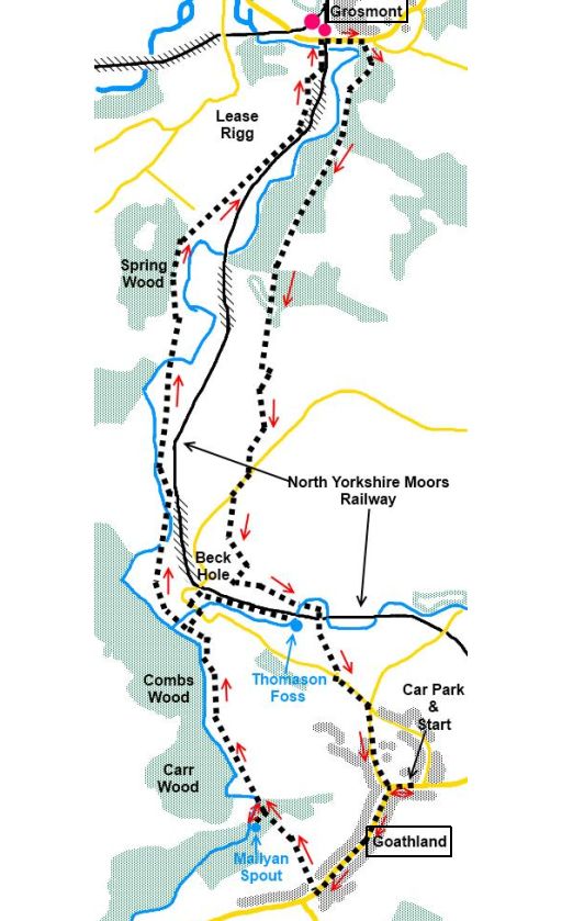
39. Grosmont
North York Moors National Park
5 km ........ licht
Mix country walking with a steam train journey through a
beautiful landscape of moors, woodlands and becks.
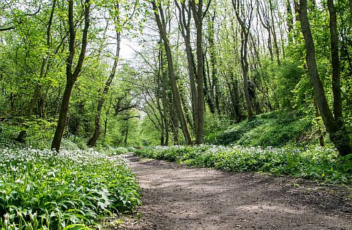
This popular countryside walk follows the old railway line between Grosmont and Goathland in the heart of the North York Moors National Park.
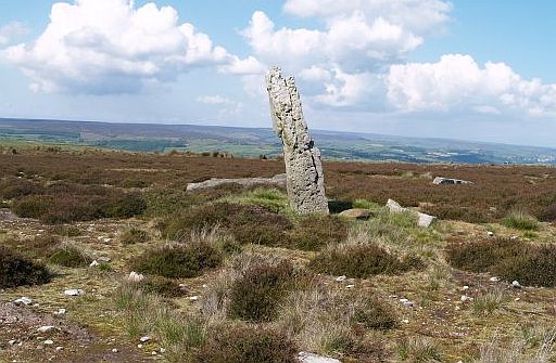
You’ll stroll through shady woodlands, across moors, past standing stones, alongside fast-flowing becks and through the hamlet of Beck Hole – with its charming tiny pub and sweet shop – towards the village of Goathland, made famous by the TV series Heartbeat.
Much of this 3-mile walking route is downhill so it’s easy on your legs, and you can save your energy even further by catching a steam train back to your start point on the North Yorkshire Moors Railway.
The NYMR is a fully accredited museum and operated by a charitable
trust
with 550 volunteers, providing a wonderful visitor experience for
tourists
all year round.
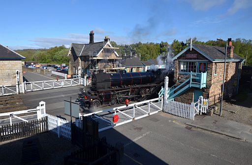
• Spoorwegovergang Grosmont met stoomlocomotief.
• Zo wandelt: http://theoutdoorguide.co.uk
•Zo wandelt: www.happyhiker.co.uk/
Start / finish: Grosmont
Walk from Grosmont to Goathland over the moors and walk back .or catch a train back.
ANWB Campings:
Zie voor een overzicht anwb.nl/engeland
Wildkamperen (bivak):
Gaf mij geen problemen.
Verdere info:
www.happyhiker.co.uk/MyWalk
.................................................
https://osmaps.ordnancesurvey.
...Wandelgids: Kaart: Te bestellen bij: |
| aaaa |
49
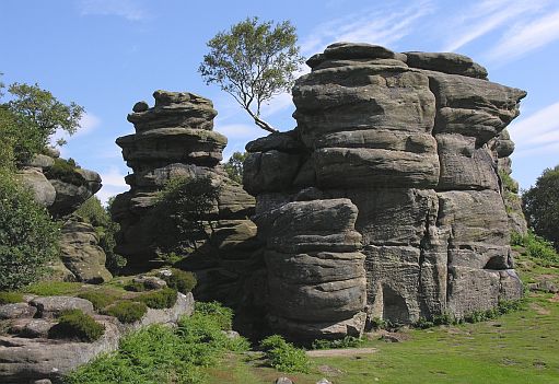
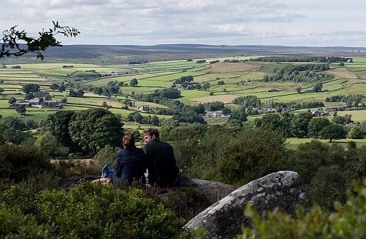
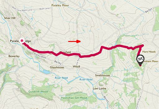
49. Brimham Rocks
Nidderdale AONB
6½ km ... middelzwaar
Great Yorkshire scenery, great walking and great rock formations. What more could you want?
This is a beautiful walk from the village of Pateley Bridge to the crazy gritstone formations of Brimham Rocks.
... Grit — A sediment comprising coarse sand grains. .. Gritstone (Millstone grit) — A coarse-grained sandstone...... |
The amazing balancing rock towers were created by an enormous river that dominated this landscape around 100 million years before dinosaurs walked the Earth, with wind and ice sculpting them into the weird and wonderful shapes found at Brimham Rocks today.
There are many walking trails in the area, and you can drive to the rocks if you’re feeling lazy, but this route from Pateley Bridge allows you to savour a classic Yorkshire landscape. Stop off at the village’s famous sweet shop to stock up on treats before setting off, then wander through a mixture of rivers, moors, valleys and woodlands on your way to the Brimham Rocks SSSI (Site of Special Scientific Interest).
One of the north of England’s natural wonders, the rocks are a mass
of
giant gritstone boulders eroded into strange forms.
There are a range of trails around the area but the route from the
village
of Pateley Bridge is a walk which takes you along rivers,
moors, valleys
and woodlands.
. 
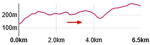
Totale stijging = 300 m
Start: Pateley Bridge
Finish: Brimham Moor
The Brimham Explorer 825 bus runs direct to Brimham Rocks from
Ripon, Fountains Abbey and Pateley Bridge; but always check the
timetables before relying on it for your return journey.
ANWB Campings:
Zie voor een overzicht anwb.nl/engeland
Wildkamperen (bivak):
Gaf mij geen problemen.
Verdere info:
www.dave-ford.co.uk/Brimham
..................................................
www.visitharrogate.co.uk/thing
.................................................
https://osmaps.ordnancesurve
....Wandelgids: Kaart: Te bestellen bij: |
| aaaa |
50
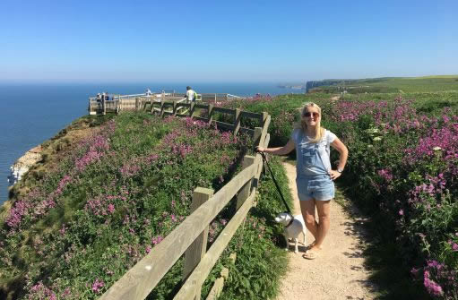
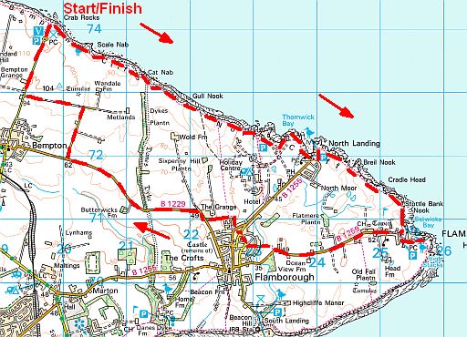
50. Bempton Cliffs
RSPB Reserve
19 km ... middelzwaar
5 km schitterende krijtrotsen (soms tot 120 m, de hoogste van
Brittannië)
ten noordwesten van Flamborough Head, Humberside.
Het zijn de meest zuidelijk gelegen zeevogelrotsen
aan de oostkust,
met
de enige broedkolonie jan-van-genten op het Britse vasteland.
In het broedseizoen krioelen de richels van de nestelende vogels.
Bempton Cliffs is the best place in England to experience the hustle
and
bustle of a breeding seabird colony.
Every year from March to October more than 200,000 birds nest on
the
towering white chalk (=krijt) cliffs, including:
- Puffin = Papegaaiduiker
- Kittiwake = Drieteenmeeuw
- Herring gull = Zilvermeeuw
- Gannet = Jan-van-gent
- Guillemot = Zeekoet
- Razorbill = Alk
- Fulmar = Noordse stormvogel
- Shag = Kuifaalscholver
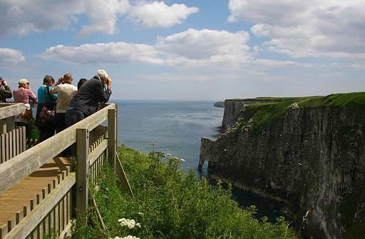
Walk the well-maintained paths and visit the six viewing platforms along
3 miles of chalk cliffs
as these are the best spots.
A visit to the protected area in summer is an experience you will
never
forget. The sight, sound and even smell of 200,000 breeding
seabirds
will remain
with you for a long time !
See also the remains of the RAF radio station, the haunting shipwrecks along
the coast and the lighthouse at Flamborough Head.
Seals and porpoises are common sights from the cliff-tops, with walkers
also reporting sights of basking sharks and whales lurking in the depths.
From Flamborough Head you can either retrace your steps along the
cliffs,
or follow inland country lanes back to the RSPB reserve and its
welcoming cafe.
• A well-maintained path with six viewing platforms.
streetmap.co.uk
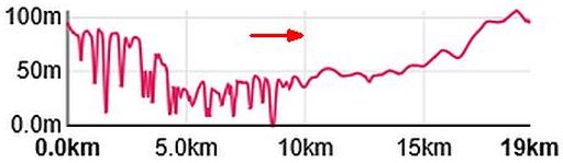
Totale stijging = 1060 m
Start / finish:
The car park at the RSPB’s Bempton Cliffs nature reserve.
ANWB Campings:
Zie voor een overzicht anwb.nl/engeland
Wildkamperen (bivak):
Gaf mij geen problemen.
Zie voor een goede introductie van de verschillende kustvormen:
engeland_coastal-landscapes
Verdere info:
www.yorkshirecoastnature.co.
................................................
www.rspb.org.uk/globalassets
..................................................
www.trouw.nl/nieuws/op-de-vo
Wandelgids: Kaarten: OS Explorer 301, 295 Te bestellen bij: |
| aaaa |
54
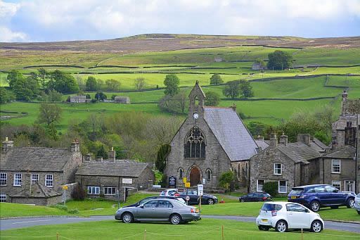
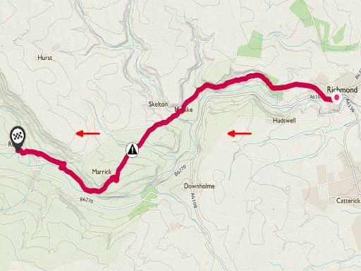
54. Richmond - Reeth
Yorkshire Dales National Park
7 km ... middelzwaar
.
A wonderful Dales day walk, but beware – it may convince you to
tackle
all 190 miles of the Coast to Coast!
This linear walk follows a stunning section of Alfred Wainwright’s
famous Coast to Coast Walk from Richmond to Reeth in the
Yorkshire Dales
National Park.
The entire Coast to Coast Walk runs for 190 miles from St Bees in
Cumbria
to Robin Hood’s Bay in North Yorkshire, but this popular section
provides
a great single day walk in Lower Swaledale in the north-eastern
corner of
the Dales.
Starting in the historic market town of Richmond – with its Georgian architecture and Norman castle – and exploring the cascading rivers, ruins and meadows of Lower Swaledale, this route shows off everything that makes the Dales such a popular place to walk.
You’ll finish in the village of Reeth, which marks the meeting point of Swaledale and Arkengarthdale, and is described as a natural amphitheatre. This former Saxon settlement is a wonderful place to end the
walk, where
you can unwind in a comfy pub with a pint and a
home-cooked meal.
• Reeth, the largest village in Swaledale:
- Vooraan: . the large sloping village green with the houses and church on its fringes.
- Daarachter:....the hay meadows ( full of wildflowers in June !). These fields are surrounded by dry stone walls and
dotted with stone field barns to store the hay.
.- En bovenaan:..the upland heathland ( the wild, open heather moorland).
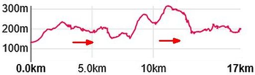
Totale stijging = 660 m
Start: Richmond.
Finish:Reeth.
There is a bus between Richmond and Reeth.
ANWB Campings:
Zie voor een overzicht anwb.nl/engeland
Wildkamperen (bivak):
Gaf mij geen problemen.
Verdere info:
https://osmaps.ordnancesurvey.
...Wandelgids: Kaart: Te bestellen bij: |
| aaaa |
61
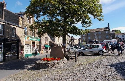
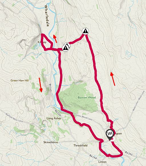
61. Grassington
Yorkshire Dales National Park
15½ km....... middelzwaar
A hell of a lot of Dales landscape packed into one relatively short circular route. Grassington is a wonderful place for walkers.
This circular walk in the Yorkshire Dales National Park starts in the
pretty village of Grassington and visits Linton Falls, Kilnsey Crag and
Conistone
Dib.
If you’ve never visited Grassington, start planning your trip now.
The narrow streets of this beautiful stone village in Upper Wharefdale are packed with pubs, cafes and shops – making it an ideal location
for
walkers planning to explore the Dales on foot.
The impressive cascades of Linton Falls lie to the south of the village,
and
as you follow this route north you’ll begin to appreciate the area’s
stunning limestone scenery at Kilnsey Crag and the narrow gorge of Conistone Dib.
Not to be confused with Coniston in the Lake District, Conistone village is
a lovely place to stroll through, with the fast-flowing waters of the River Wharfe a regular companion for much of this beautiful route.
If you want to add some variety to your walk then explore trees and
wildlife
of Grass Wood Nature Reserve – the largest area of broadleaved woodland
in the Dales – on your return journey to Grassington.
• Grassington.
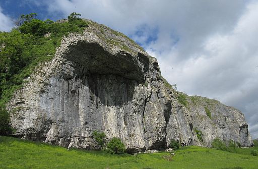
• Kilnsey Crag is one of Wharfedale's most prominent landmarks.
• It is a truncated spur (= afgeknot spoor). The end of a protruding nose of limestone was effectively trimmed off by the Wharfedale Glacier some 12,000 years ago.
• The overhang has always been a serious challenge for climbers.
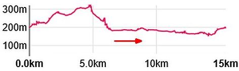
Totale stijging = 370 m
Start / finish:
Grassington
ANWB Campings:
Zie voor een overzicht anwb.nl/engeland
Wildkamperen (bivak):
Gaf mij geen problemen.
Verdere info:
https://osmaps.ordnancesurvey.
Zie vooraf ook de uitgebreide introductie:.
engeland_upland-limestone-landscapes
Wandelgids: Kaart: OS Explorer OL2 Te bestellen bij: |
| aaaa |
69
69. Brontë Way
Yorkshire ..... dit is upland
13½ km ... middelzwaar
This walk explores Haworth and the Haworth Moors made famous by
the Brontë sisters.
Haworth is the village where the Brontë sisters – Charlotte, Anne and
Emily – lived and wrote, surrounded by the dramatic moorlands that
inspired their legendary literary work.
The Parsonage was their home, nowadays a museum.
Haworth itself is a lovely village to explore, with its steep cobbled main
street, quirky shops and good pubs.
Set off from the village to Haworth Moor and walk along the
landscapes
that feature in their stories.
You’ll reach the Brontë Waterfall first, which is
a stunning spot
famously described by Charlotte Brontë as a
‘perfect
torrent racing over the rocks, white and beautiful’.
This small fall is best to visit after heavy rain with water flowing fast down
the rocks, as it can slow to a trickle in the dry summer months.
From the fall keep heading up to Top Withens, a ruined farmhouse
said to have been the inspiration for Wuthering Heights in Emily Brontë’s novel.
You’ll follow the Pennine Way for part of the return journey, passing
Lower Laithe Reservoir before finishing back in Haworth.
Keep an eye out for birds as you walk, with peregrines (slechtvalken),
curlews (wulpen), merlins (smellekens), and golden plovers all
breeding
around Haworth Moor.
And remember to pack your waterproofs because these hills are
renowned
for being wet !
.... Haworth a former textile manufacturing village, was the home of
the Bronte family. |
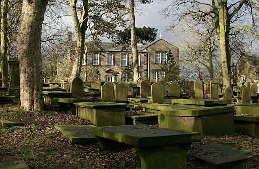
• Brontë Parsonage, Haworth. This was the place where astonishing art was created by three sisters.
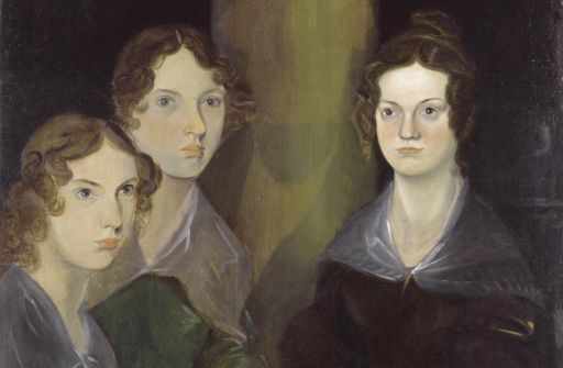
• Anne, Emily en Charlotte Brontë, geschilderd door hun broer Branwell (ca. 1834).
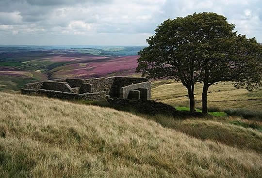
• Top Withens, Haworth Moor (upland acid grassland and upland heathland). This ruined farmhouse said to have been the inspiration for Wuthering Heights in Emily Brontë's novel.
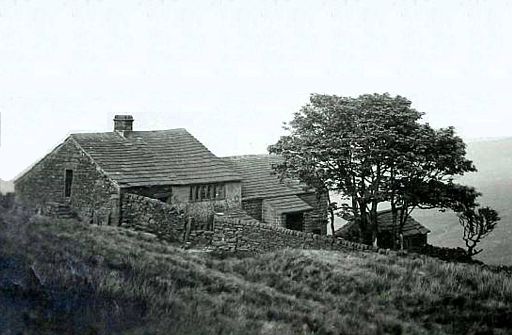
• Top Withens in the 1920s.
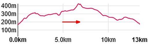
Totale stijging = 440 m
Hier heb je upland (= land lying above the limit of enclosed farmland.)
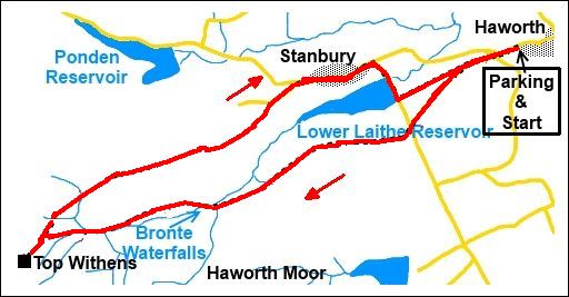
Start / finish: Haworth.
ANWB Campings:
Zie voor een overzicht anwb.nl/engeland
Wildkamperen (bivak):
Gaf mij geen problemen.
Verdere info:
www.beautifulenglandphoto
.............................................
https://osmaps.ordnancesur
Wandelgids: Kaart: OS Explorer OL21 , 297 Te bestellen bij: |
| aaaa |
81
81. Leeds & Liverpool Canal
Yorkshire.
25½ km (middelzwaar vanwege lengte
Skipton to Saltaire
• A popular section along this 127 mile canal includes a visit to Saltaire, a designated UNESCO World Heritage site.
On the outskirts of Keighley you can see the Bingley Five-Rise Locks, one
of
the ‘Seven Wonders of the Waterways’.
• This canal was planned to be the first to cross the Pennines.
Its construction was decided in 1770 and already in 1773; the first stretch
from Skipton to Bingley was opened. It was a stretch with no locks,
though!
Then, works were suspended several times for the lack of money.
Only 46 years later, the canal was finally opened. It was the last one in this area and the costs for it were five times higher than planned.
The biggest handicap was then the complexity and variety of the
route.
Today, exactly these handicaps make this canal to be one of the most interesting waterways at all.
Noord-Engeland (Rother Wandelgidsen) heeft van het Leeds & Liverpool Canal ook een korte wandeling van 3 uur:
Tocht 35 . Leeds & Liverpool Canal bij Gargrave.
Dit ligt ongeveer 5 km ten noordwesten van Skipton.
Kaart: OS Explorer OL2
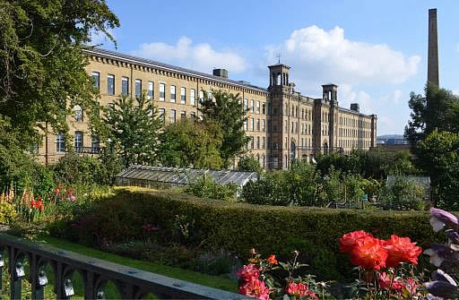
• Salts Mill , Saltaire.
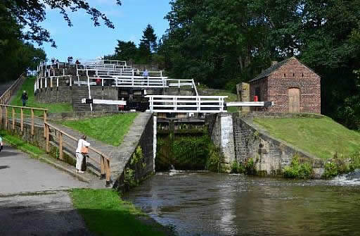
• Bingley Five-Rise Locks (= sluizen).
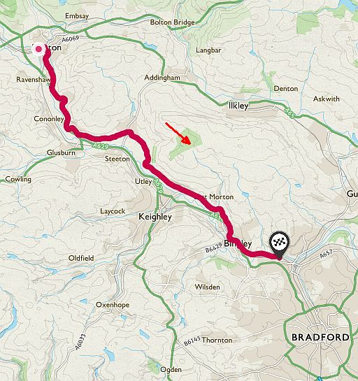
Start: Skipton.
Finish: Saltaire.
There is a bus.
ANWB Campings:
Zie voor een overzicht anwb.nl/engeland
Wildkamperen (bivak):
Gaf mij geen problemen.
Verdere info:
www.european-waterwa
.......................................
https://osmaps.ordnance
... Wandelgids: Kaart: Te bestellen bij: |
| aaaa |
..Deze wandelsite is niet-commercieel, onafhankelijk en gratis. Dat is enkel mogelijk door steun van de bezoekers. Uiteraard kun je ook doneren door overschrijving op mijn |
Weet je aanvullingen en verbeteringen van deze tekst?
Graag een e-mail naar:
![]()
![]() ...
... ![]() ....
.... ![]()
LAATST BIJGEWERKT : 7-1-2019