.
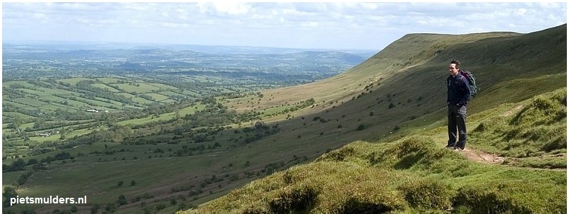
.......... UPLANDS IN WALES.
Upland:
= land lying above the limit of enclosed (omheind) farmland. Die grens ligt gewoonlijk op grofweg 1,000 feet (±300m) boven
zeeniveau.
Het is dus alles boven de Fell wall, m.a.w. de Open fell, dus de Outfield.
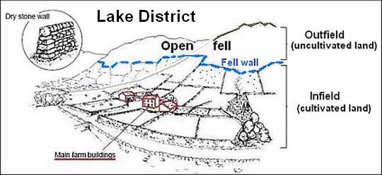
• Als voorbeeld een boerderij in het Lake District in Noord-Engeland.
• Het upland is de Open fell boven de Fell wall, dus de Outfield (het buitengebied, de wildernis, het onbewerkte gebied).
Infield-outfield farming:
Infield-outfield farming is broadly defined as a type of farming system utilizing its area at two different levels of intensity: an intensively farmed infield and an outfield exploited at a low intensity.
(In het Noors noemt men ze Innmark en Utmark)
![]() Infield = het binnengebied, d.w.z.
Infield = het binnengebied, d.w.z.
1. het bewerkte gebied (cultivated land; in cultuur gebrachte gebied).
2. dicht bij de boerderij.
De infield wordt intensief gebruikt. Denk aan ploegen, maaien, bemesten.
![]() Outfield = het buitengebied, de wildernis), d.w.z.
Outfield = het buitengebied, de wildernis), d.w.z.
1. het onbewerkte gebied (uncultivated land ; niet in cultuur gebrachte gebied),
2. ver van de boerderij.
De outfield wordt extensief gebruikt bijv. voor 't weiden van vee.
Ook in Nederland kenden we in het verleden infield-outfield farming. Denk aan het esdorpenlandschap, waar de essen(1) en de groenlanden (2) (de graslanden (wei- en hooilanden) in het beekdal) samen de infield vormden. De heide(3) was de outfield.
Upland habitats in Britain:
• Covering about a third of the UK’s land surface, upland habitats form the
bulk
of our wildest, most scenic and possibly most romantic countryside.
They are the open habitats of mountains,
moors (venen), blanket bogs (spreihoogvenen) , heaths and rough grasslands.
•The setting for many atmospheric novels from Wuthering Heights to
The Hound of the Baskervilles.
•The uplands are characterised by:
1. older, harder, more resistant rocks, which
form blocks of higher ground.
2. the soils are often less fertile making them less favourable for farming.
3. the climate, tends to be more severe.
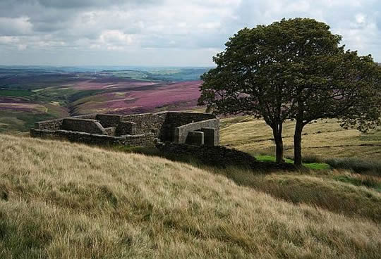
• Top Withens, Haworth Moor. This ruined farmhouse, is the supposed setting for Wuthering Heights in Emily Bronte's novel.
Krantenartikel:
George Monbiot: Why Britain's barren uplands have farming subsidies
to blame.
The hills have been grazed to destruction and it's time we
begin to
challenge
the irrational aspects of the farming funding system.
Zie: www.theguardian.com/e
Video ( 9 minuten):
George Monbiot: hills are 'sheep-wrecked' and in danger
Zie: www.youtube.com/watc
Mooie video: Rewilding (= herwildering) with George Monbiot:
George Monbiot:
Cross that bleak plateau and you will see plenty of moorgrass, some
tormentil
and moss, a few crows, perhaps the odd pipit and skylark, but
almost nothing
else, except sodding sheep. The hills have been grazed to
destruction'.
We zien een frappant verschil tussen de uplands van
het Europese
vasteland
en die van Groot-Brittannië (en Ierland).
Die van het continent zijn bebost (denk bijv. aan de Ardennen).
Dat is de normale gang van zaken bij uplands met hun relatief
ruige klimaat
en arme
bodem.
In Groot-Brittannië zijn ze echter niet bebost (denk aan de kale Pennines).
George Monbiot legt in een prachtige lezing uit hoe dat komt.
Warm aanbevolen.
Zie: www.youtube.com/watch?v=
...Rewilding (herwildering) = the mass restoration of ecosystems. |
.... Upland areas in Britain: Op de onderstaande kaart kun je de uplands goed vergelijken tussen Engeland, Schotland en Wales.
Schotland en Wales hebben beide relatief veel upland. In Schotland
is een groot
gedeelte daarvan zelfs boven de 2,500 ft (±760 m).
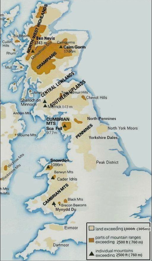 • De uplands zijn in de kaart de licht- en donkerbruine gebieden samen. • Most of our upland habitats are found in Scotland, Northern England and Wales, though there are some areas of moorland in South West England. • Towards the north of Britain the climate, soils and terrain become more challenging for plants and animals, so that some areas almost at sea level in Northern Scotland or the Hebrides still feel part of the upland rather. than the lowland zone..... |
..... What are uplands ?
Although the word upland and this definition, implies an altitudinal
boundary,
the altitude (=hoogte) of the land is really a surrogate for climate, since the
position of the boundary between lowland and upland is related to the effect
that weather has
on plant growth. |
Important upland semi-natural habitats:
Most of the uplands have been modified through grazing, drainage,
tree-planting and deposits of atmospheric pollution.
The uplands are perhaps most memorable characterised by
a mosaic of bleak, open unenclosed(=niet omheind) landscape of:
1. Blanket bog (=spreihoogveen),
2. Upland Heaths,
3. Upland Grassland
.....1. Blanket bog (=spreihoogveen): As the name suggests, blanket bogs form over a large area and are
typically
shallow (a few metres). Blanket bog (=spreihoogveen): is an open habitat almost entirely restricted to the uplands in England and Wales, but which descends to sea level in parts of
Scotland.
• Blanket bogs by region based on 5 km gridded data of blanket peat presence. |
.... 2. Upland heaths : 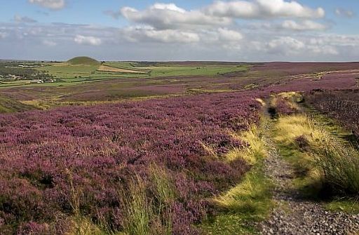 • Upland heath ( heather moor) in the North York Moors. • Het is niet omheind (unenclosed) heideveen dat beheerd wordt voor grouse shooting. . Upland heath occurs on steeper slopes than blanket bog. It occurs on mineral soils and thin peats < 0.5 m, and is characterised by a cover of dwarf shrubs of at least 25%. (Blanket bog is distinguished from heathland by its occurrence on deep peat (> 0.5m) and gentler slopes.) Typical shrub species include: - Heather (Calluna vulgaris) (Struikhei), - Bilberry (Vaccinium myrtillus) (Blauwe bosbes), - Crowberry (Empetrum nigrum) (Kraaihei) and - Bell heather (Erica cinerea) (Rode dophei). - Juniper (Jeneverbes) is often found on upland heaths in northern areas, whilst - Western gorse (Ulex gallii) (Westelijke gaspeldoorn) occurs in the south and west. Wet heath is more commonly found in the north and west where the climate is damper. Here typical plant species are: - Cross-leaved heath (Erica tetralix) (Gewone dophei), - Deer grass (Scirpus cespitosus) (een Bies-soort), - Heather and Purple moor grass (Molinia caerulea) (Pijpenstrootje) , - with a carpet of mosses including Sphagnum species. (Veenmos spp) http://www.peakdistrict.gov.uk .... |
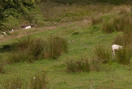
.... 3. Upland grassland:
Upland grasslands are the result of human intervention through
livestock grazing. |
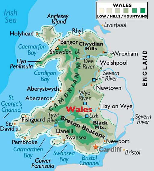
... Belangrijkste upland regions in Wales: 1. Snowdonia N.P. ( 1085 m), |
| ...Upland areas in Wales .)(. |
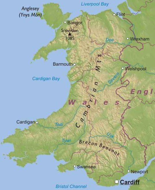
| ...Upland areas in Wales .)(. |
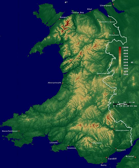
Wales is grotendeels upland.
Alleen de lagere delen langs de
kust en in Pembrokeshire zijn lowland.
(Zie bijv. het hoogteprofiel bij mijn pagina
van Glyndwr's Way...Daar wandel je tussen de 400 m en 500 m hoogte)
.... Upland = land lying above the limit of enclosed (omheind) farmland. Die grens ligt gewoonlijk op grofweg 1,000 feet (± 300m) boven
zeeniveau. |
| ...Nationale parken in Wales .)(. |
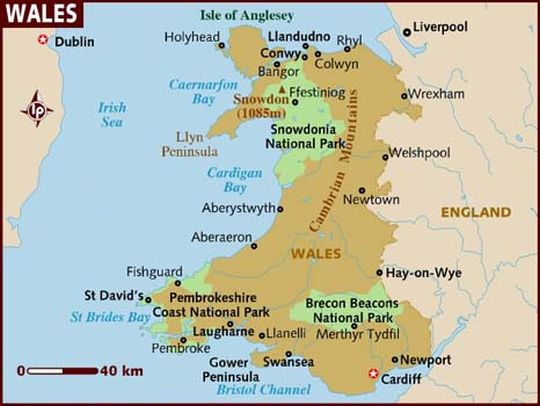
...Geography: • Wales is hilly, and for the most part, a mountainous country, dominated
by the Cambrian Mts , central and north, and by the Brecon Beacons of the south. |
Weet je aanvullingen en verbeteringen van deze tekst?
Graag een e-mail naar:
![]()
![]() ....
.... ![]() ....
.... ![]()