|
.
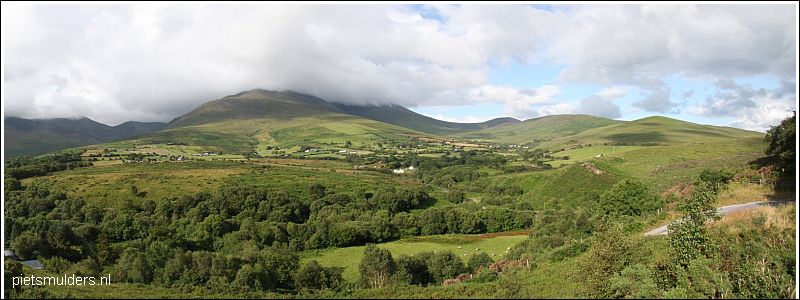
....... .... UPLANDS IN IERLAND
.
Upland = land lying above the limit of enclosed (omheind) farmland.
Die grens ligt gewoonlijk op grofweg 1,000 feet (± 300m) boven zeeniveau.
Uitgezonderd de westkust. Daar vind je al vegetatie met
een
upland-
karakter op veel lagere hoogte, soms zelfs op zeeniveau. |
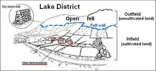
• In de tekening is het upland alles boven de Fell wall. Het is dus de open fell.
• Upland areas = land lying above the limit of enclosed farmland,
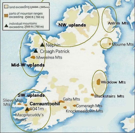
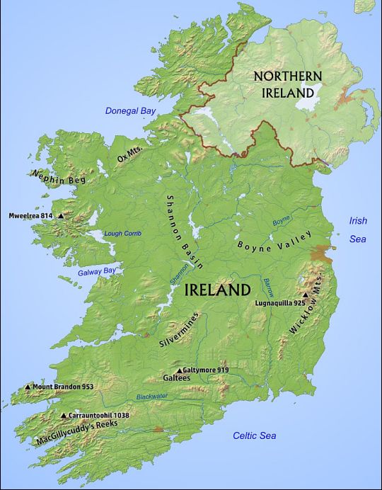
.. grofweg alles hoger dan 1,000 feet ( = geel en bruin) in deze kaart.
• Daarnaast zijn er langs de westkust nog lager gelegen gebieden waar de vegetatie
.. een upland. karakter heeft, soms zelfs tot op zeeniveau.
• Upland areas = land lying above the limit of enclosed farmland,
.. grofweg alles hoger dan 1,000 feet ( = geel en bruin) in deze kaart.
• Daarnaast zijn er langs de westkust nog lager gelegen gebieden waar de vegetatie
.. een upland. karakter heeft, soms zelfs tot op zeeniveau.
Important upland semi-natural habitats:
Most of the uplands have been modified through grazing, drainage,
tree-planting and deposits of atmospheric pollution.
The uplands are perhaps most memorable characterised by
a mosaic of bleak, open unenclosed (= niet omheind) landscape of:
1. Blanket bog (= spreihoogveen),
2. Upland Heaths,
3. Upland Grassland
.
1. Blanket bog (= spreihoogveen):
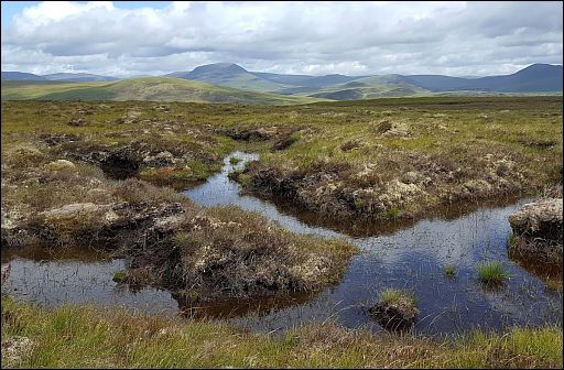
As the name suggests, blanket bogs form over a large area and are
typically
shallow ( a few metres).
They form in areas of high rainfall (upland areas + west coast) where
high levels
of acid leaching occur.
They are called blanket bogs because of their appearance - from a
distance they appear homogeneous and they hug the topography
like a blanket. Contrary to popular belief, blanket bogs are essen-
tially a man-made feature, if inadvertent (onopzettelijk) and aided
somewhat by the climate.
Blanket bog is an open habitat almost entirely restricted to the uplands
in
England and Wales, but which descends to sea level in parts of
Scotland and Ireland.
It is characteristically underlain by an expansive ‘blanket’ layer of peat.
This develops because the climate is sufficiently cool and damp to
allow peat-forming plants to grow – the litter of which decomposes
very slowly
under
the permanently water-logged conditions and
gradually accumulates
into a
layer of peat.
(Examples of species are Sphagnum mosses and cotton grasses).
The peat depth and time over which it has accumulated are very
variable –
usually it is between 0.5–3 m thick and dates back
5–6,000 years.
The main causes of the spread of blanket bog are debated – although
in
some
areas this initiated following clearance of the original forest
cover by
man, this
co-incided with a general natural cooling in climate
conditions.
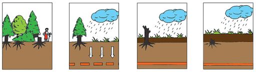
Formation of Blanket Bogs
Blanket bog formation in the uplands and west coast started at the end
of the last glaciation, 10,000 years ago.
Initially peat formation was confined to shallow lakes and wet hollows.
Over time an infilling sequence from open water to fen and acid peat
occurred to form the blanket bog habitat we find today.
Later, acid peat spread out to form a blanket covering huge areas of
poorly drained land. While some spread may have taken place as early
as 7,000 years ago, many areas were not engulfed until 4,000 years ago
when the climate became wetter.
Heavy rainfall caused minerals such as iron to be washed out or
leached from the surface layers of the soil, a process know as
paludifacation.
These were deposited lower down where they formed an
impermeable layer known as an iron pan. Water cannot move down
through such a layer and the soil surface became waterlogged as a
result. Under these conditions the accumulation and spread of peat
was made possible.
Importance of Blanket Bogs
Blanket bogs are valuable wetlands, not wastelands. There are a
number of reasons for conserving blanket bogs.
- Only a small amount of blanket bog exists in the world. Ireland possesses 8% of the world’s blanket bog and is the most
important country in Europe for this type of habitat.
- Blanket bog landscapes provide a refuge for a rich biodiversity
of species.
- Blanket bogs are commonly used as rough grazing land for sheep
and cattle, grouse shooting, deer stalking and fishing.
- Blanket bogs preserve prehistoric farming landscapes beneath
the peat as well as a diverse range of artefacts within the peat
mass.
- The patterns of pools on the flatter areas of blanket bog is of
particular conservation significance. The pools support a
specialised range of mosses (especially species of Sphagnum)
and
plants and they provide essential feeding habitats for wetland
birds.
- Within their peat layers, blanket bogs preserve a record of their
own growth and development and on a larger scale, they provide insights into regional vegetation change, climate change,
atmospheric pollution and act as chronometers for other events
such as volcanic eruptions.
- Blanket bogs accumulate and store millions of tonnes of carbon
and have a vital function in controlling the green house gases
that
cause climate change.
- Blanket bogs contain in excess of 90% water and act as vast water reservoirs. They have a vital role to play in the management of
water within river catchments.
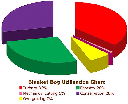
Extent and Utilisation of Blanket Bog
Although blanket bogs originally covered more than 774,367ha of the
land surface in the Republic of Ireland,
-
hand cutting over 400 years,
-
the introduction of large-scale, mechanised turf extraction,
-
afforestation programmes,
-
intensification of agriculture and land reclamation
have seriously depleted the area of blanket bog suitable for conservation.
Only 28% of the blanket peatland resource remains in a relatively intact condition in the Republic of Ireland.
Traditional cutting of the bogs for turbary is having a serious impact on
blanket bogs. 36% of the blanket bogs have been cutaway by this
process. Peat is still being cut privately.
Grazing pressure on blanket bogs although particularly severe during
the last century mainly by cattle did not result in degradation of this
habitat. Sheep replaced cattle as the principal grazing animal with the introduction of EU farming subsidies in the 1980’s and have caused
severe erosion and complete loss of sites. Overgrazing has led to
erosion and habitat loss of 7% of the area of blanket bog since 1980
and in 2000 a further 7% was deemed threatened by this activity.
Large-scale afforestation schemes have had a huge impact on
blanket bogs with planting on 28% of the original area within the
Republic of Ireland.
EU and Government incentives introduced since the mid 1990’s have
resulted in an interest in wind energy developments which seriously
degrade the integrity of mountain blanket bogs.
Another cause of blanket bog degradation is the colonisation of the
habitat by invasive alien species such as Rhododendron ponticum and
Pinus contorta.
........ 
www.ipcc.ie/a-to-z-peatlands/blanket-bogs/ |
.
2. Upland heaths : .Upland heath occurs on steeper slopes than blanket bog.
It occurs on mineral soils and thin peats < 0.5 m, and is characterised
by a cover of dwarf shrubs of
at least 25%.
(Blanket bog is distinguished from heathland by its occurrence on
deep peat (> 0.5m) and gentler slopes.)
Typical shrub species include Heather (Calluna vulgaris), Bilberry
(Vaccinium myrtillus), Crowberry (Empetrum nigrum) and
Bell heather (Erica cinerea).
Juniper is often found on upland heaths in northern areas, whilst
Western gorse (Ulex gallii) occurs in the south and west.
Wet heath is more commonly found in the north and west where the
climate is damper. Here typical plant species are
Cross-leaved heath (Erica tetralix), Deer grass (Scirpus cespitosus),
Heather and Purple moor grass (Molinia caerulea), with a carpet o
f mosses including Sphagnum species.
|
.
3. Upland grassland:
 • Upland acid grassland and rush pasture. • Upland acid grassland and rush pasture.
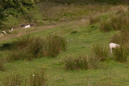
Upland grasslands are the result of human intervention through livestock grazing.
They are generally unenclosed and subjected to extensive livestock
grazing.
Underlying geology, soil type and historic land use are significant
drivers of distribution.
The most common grassland is acid grassland consisting of bents,
fescues, mat-grass and wavy-hair grass.
More nutritious grasslands occur on areas of fertile or lime-rich soils. |
Mooie video: Rewilding (= herwildering) with George Monbiot:
George Monbiot:
Cross that bleak plateau and you will see plenty of moorgrass, some
tormentil
and moss, a few crows, perhaps the odd pipit and skylark, but
almost nothing
else, except sodding sheep. The hills have been grazed to
destruction'.
We zien een frappant verschil tussen de uplands van
het Europese vasteland
en die van Groot-Brittannië (en Ierland).
Die van het continent zijn bebost (denk bijvoorbeeld aan de Ardennen).
Dat is de normale gang van zaken bij uplands met hun relatief
ruige klimaat
en arme
bodem.
In Groot-Brittannië zijn ze echter niet bebost (denk aan de kale Pennines).
George Monbiot legt in een prachtige lezing uit hoe dat komt.
Warm aanbevolen.  www.youtube.com/watch?v=ZHw8yiHD4Iw www.youtube.com/watch?v=ZHw8yiHD4Iw
Weet je aanvullingen en verbeteringen van deze tekst?
Graag een e-mail naar:

 .... ....  .... ....
LAATST BIJGEWERKT : 7-1-2019
|
|