.
GLACIATED . UPLAND . LANDSCAPES
A glaciated (vergletsjerd) upland is an upland area that has
been eroded by ice.
.... Snel naar: A. Glacial erosion landforms: B. Location of glaciated uplands C. Two processes of glacial erosion
. |
A. Glacial erosion landforms:
(landforms = landvormen, reliëfvormen)
Hoofdstuk1
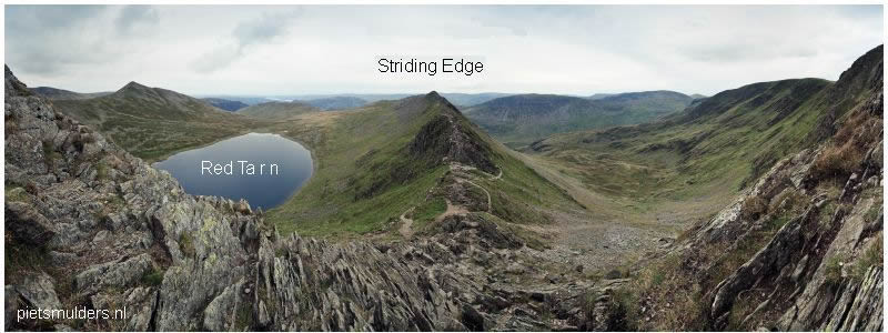
1. Corrie/Cwm/Cirque
...... kaar (Ned.) ... botn (Noors)
Corrie = an armchair-shaped hollow (nis) with steep sides and back wall, formed as a result of glacial erosion high on
a mountainside, and sometimes containing a rock basin with a tarn (corrie loch) (kaarmeertje).
- In Wales they use the name cwm in stead of corrie.
- The French name cirque is also used by some people.
STAGE 1
At the start of the Ice Age, snow collected in a hollow (nis) high up in
the
mountains and was gradually squeezed into ice.
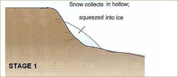
As more and more snow built up, it filled the hollow and some of it was
then
squeezed out and forced down the mountainside.
This was the starting point of a glacier.
STAGE 2
The hollow in which the snow and ice collected was eroded by the ice
to
form a much deeper, steeper hollow. This is a corrie (kaar).
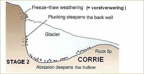
As the meltwater under the ice seeped into cracks (scheuren), the rock in the
hollow
was weathered by freeze-thaw action (vorstverwering).
Then, when the meltwater froze onto the rock, plucking (=plukken) took place.
The back wall, sides and base of the hollow were eroded very quickly
by
these two processes.
At the lip of the hollow (kaardrempel) the ice was less thick and so did less plucking.
But by now, there were fragments in the bottom of the glacier and so the
rock lip was abraded (=geschuurd), making it smoother.
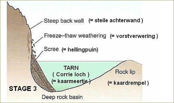
STAGE 3
When the ice finally melted at the end of the Ice Age, a corrie was
sometimes deep enough to be filled with meltwater and so formed a tarn (corrie loch), botnsjø (Noors) (kaarmeertje).
For example: Red Tarn on the eastern flank of Helvellyn.
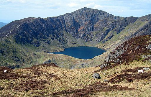
• Fig: The Corrie of Cwm Cau on the peak of Cadair Idris, Snowdonia National Park, Wales
| aaaa |
Hoofdstuk2
2. Arête
..... graat (Ned.) ... egg (Noors)
Arête =
a sharp ridge (scherpe kam) of rock separating two corries.
On many mountains in Britain there is not just one hollow high up near
the
summit, but several. So while a glacier was eroding a corrie on one
side of
a mountain, the other sides would have other glaciers eroding
more corries.
Where two corries formed back to back (rug-aan-rug) or side by side, the rock between
them was plucked (geplukt) to form a sharp ridge (scherpe kam) , shown in figure
below.
This sharp ridge is called an arête (graat).
For example: Striding Edge near Helvellyn in the Lake District.
| aaaa |
Hoofdstuk3
3. Pyramidal peak / Horn
.....piramidevormige piek (pigg in Noors)
Pyramidal peak = a sharply pointed (spitse) mountain peak that has been formed by glaciation.)
Where three or more corries formed back to back (rug-aan-rug), the rock between them
was weathered (verweerd) and plucked (geplukt) into a sharp point called a pyramidal peak (piramidevormige piek).
For example: Snowdon, Mont Blanc, Matterhorn and Mount Everest.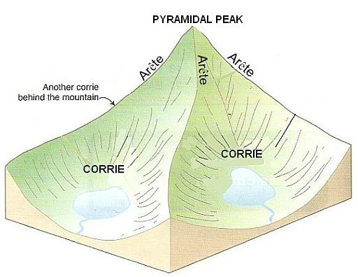
Fig: Corries, arêtes and a pyramidal peak.
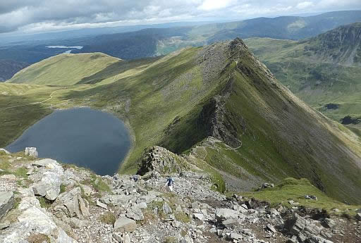
• Vanaf Helvellyn kijk je hier neer op het kaarmeer Red Tarn en de graat Striding Edge.
• Helvellyn is without a doubt one of the most popular mountains in the Lake District.
Just like the best mountains around, it has many great routes to its summit, but one
stands head a shoulders above the rest, and that is via Striding Edge.
Striding Edge is a spectacular knife edge arête (=graat) that offers a breathtaking scrambling experience. From climbing across blocks, walking across a narrow crest,
and down climbing 'The Chimney', Striding Edge has it all.
(scrambling = klauteren = naast de voeten ook je handen gebruiken)
| aaaa |
Hoofdstuk4
4. U-shaped valley
U-shaped valley; the term given to a valley when it has been eroded by glaciers. Its cross-section is U-shaped (het dal heeft een U-vormige dwarsdoorsnede).
Dalen (en fjorden) die in het Pleistoceen langdurig vergletsjerd zijn geweest, bezitten veelal een karakteristiek dwarsprofiel.
In vergelijking met niet-vergletsjerde rivierdalen, die vaak een V-vormig dwarsprofiel hebben,
zijn de dalwanden steil geworden en
zijn de dalbodems breed en vlak.
Het dwarsprofiel is daardoor meer U-vormig.
De verbreding van de dalbodems is het gevolg van de omstandigheid dat gletsjer-erosie, i.t.t. rivier-erosie, niet beperkt is tot een smalle strook onderin het dal (de rivierbedding zelf), maar plaatsvindt over de gehele door ijs bedekte oppervlakte (zie fig. 2).
Hoe diep de uitschuring is, houdt o.a. verband met de dikte van het ijs. Dalen van kleine zijgletsjers zijn vaak veel minder diep uitgeslepen dan de hoofdgletsjerdalen waarin zij uitmonden. Dit leidt, na afsmelting, tot de aanwezigheid van hangende zijdalen. (Daarentegen ligt bij rivier-erosie de dalbodem van zijdalen bij de monding als regel wel op hetzelfde niveau als de bodem van het hoofddal)
When a glacier was squeezed out of a corrie (kaar), it moved downhill under
gravity. It usually took the route of an old river
valley.
But the glacier was much more powerful than the river that was there
before, and it was able to completely change the shape and
appearance
of this valley.
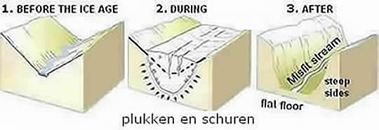
The formation of a U-shaped cross-profile.
![]() Fig. 1 Before the Ice Age: rivers in mountains ran down V-shaped valleys.
Fig. 1 Before the Ice Age: rivers in mountains ran down V-shaped valleys.
![]() Fig. 2 During the ice Age ,
when a glacier rumbled down the same valley the ice was so thick
that
it
was able to pluck (plukken) and abrade (schuren) the valley
floor (dalbodem) as well as the valley sides (dalwanden).
Fig. 2 During the ice Age ,
when a glacier rumbled down the same valley the ice was so thick
that
it
was able to pluck (plukken) and abrade (schuren) the valley
floor (dalbodem) as well as the valley sides (dalwanden).
(plucking = a type of glacial erosion that occurs when ice freezes onto the landscape, ripping out (loswrikken) rocks when it moves).
So the V-shaped valley became a U-shaped valley, with a flat
floor (bodem) and steep sides (wanden). Its cross-section (dwarsdoorsnede) is U-shaped (U-vormig)
![]() Fig. 3 After the Ice Age, now that the ice has all gone, this U-shaped valley has a river flowing
through them again. But the river is too small for this very wide
valley
and
is called misfit stream (hongerrivier).
Fig. 3 After the Ice Age, now that the ice has all gone, this U-shaped valley has a river flowing
through them again. But the river is too small for this very wide
valley
and
is called misfit stream (hongerrivier).
At the sides of the valley, scree (hellingpuin) often builds up from all the freeze-thaw weathering (vorstverwering) that has taken place on the valley sides above.
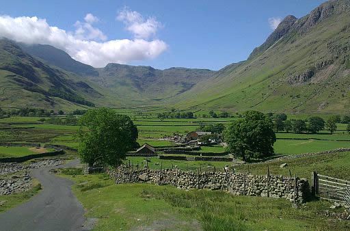
Great Langdale Valley is a U-shaped valley (dal met een U-vormige dwarsdoorsnede).
U-shaped valley — The term given to a valley when it has been eroded by glaciers. Its cross-section is U-shaped (het dal heeft een U-vormige dwarsdoorsnede)
Glacier — A mass of ice and snow which can deform and flow under
its own weight. A 'river' of ice that flows down valleys towards the
sea.
In Britain glaciers formed during the last Ice Ages and caused erosion
in upland areas (forming the typical U-shaped profile of valleys).
The eroded rock debris (gesteentepuin) was dumped when the ice melted to form moraine.
Moraine — The material eroded by a glacier and carried along by
the ice, before being dumped when the glaciers retreat.
Till is one type of moraine. It is unsorted material deposited by glaciers.
Glacial erratics (zwerfstenen) originated as moraine.
| aaaa |
Hoofdstuk5
5. Truncated spur afgeknot spoor
As it moved down the mountainside a glacier was strong enough to
keep
a straight course.
Instead of going around any obstruction, it went
over
them, quickly eroding them away. Any spurs of rock that jutted
into the
valley
were eroded away to become truncated spurs (=afgeknotte
sporen).
| aaaa |
Hoofdstuk6
6. Hanging valley often with a waterfall
Hanging valley = a smaller tributary valley which is located high above the main U-shaped valley)
Hangende dalen ontstaan doordat de erosie in het hoofddal sneller is gegaan dan in de kleinere zijdalen.
Na afsmelting van de gletsjer stort de beek in het minder diep uitgeschuurde zijdal dan plotseling over een rand in het diepere hoofddal.
Along its journey down the valley a glacier was joined by tributary glaciers (zijgletsjers).
These smaller tributary glaciers contained much less ice and so were less powerful. They could not erode their valleys as deeply as the main glacier so, where they met, the floor (dalbodem) of the tributary valley (zijdal) is much higher than the floor of the main valley.
(The tributary valley was left 'hanging' above the main valley (see figure below)
After the Ice Age, when rivers took over, the streams flowing from hanging tributary valleys often form waterfalls when they plunge into the main (U-shaped) valley.
.jpg) Interlocking spurs = hills that a river meanders around in a V-shaped valley.
Interlocking spurs = hills that a river meanders around in a V-shaped valley.
When viewed from downstream, these spurs appear to be locked together.
.jpg)
| aaaa |
Hoofdstuk7
7. Ribbon lake = langgerekt meer
.
Ribbon lake = a long narrow lake found in a glacial basin.
...
• At some points along the valley the glaciers were able to erode more deeply than elsewhere. This might have been because the rock there was
softer and more easily plucked(geplukt) and abraded(geschuurd).
It might have been
because
the ice
became thicker and therefore more powerful.
Wherever the ice did this, it made a hollow (depressie) which,
after
glaciation,
became
a lake.
The lake took on the same shape as the valley in which it was formed, so
it
was long and narrow. It is usually called a ribbon lake (langgerekt
meer).
• When
the ice reached warmer regions it melted and dropped all the pieces
of rock it had plucked and abraded (geschuurd).
This material is called.moraine (morene) and
often forms ridges (wallen).
Sometimes these ridges did
not allow
the
meltwater to escape and so lakes
built up behind them.
These moraine-dammed lakes are also examples of ribbon lakes. Many of the lakes in the English Lake District are ribbon lakes, eg Windermere.
| . |
Hoofdstuk8
B. Location of glaciated uplands:
A glaciated upland (vergletsjerd 'upland') =
an upland area that has been eroded by ice.
There are four agents (middelen) of erosion (wind, waves, rivers and moving ice) and
only moving ice does not affect the British Isles today.
Yet moving ice has had a huge effect on the shape of our landscape,
so we
must study it in detail.
Our last Ice Age ended about 10,000 years ago. The ice was so powerful
that
it left behind striking landforms (landvormen ; reliëfvormen)
that
can
be
clearly seen today.
This evidence of glaciation is most obvious when you look at our
uplands
(=alle land above the upper limit of enclosed
farmland.) Dit komt ongeveer overeen met alle land hoger dan 1,000 feet (= ± 300 m)
During the depths of the Ice Age all of Britain, except the very far south, was
buried under slowly-moving ice-sheets ( ijskappen )
(see map below)
Only in our highest mountains did conditions allow glaciers to form and
move down the mountainside like a slowly-moving "river" of ice.
When they did this, the mountains never looked the same again
because the
glaciers eroded them mercilessly.
| . Glaciated (vergletsjerde) uplands in the British Isles |
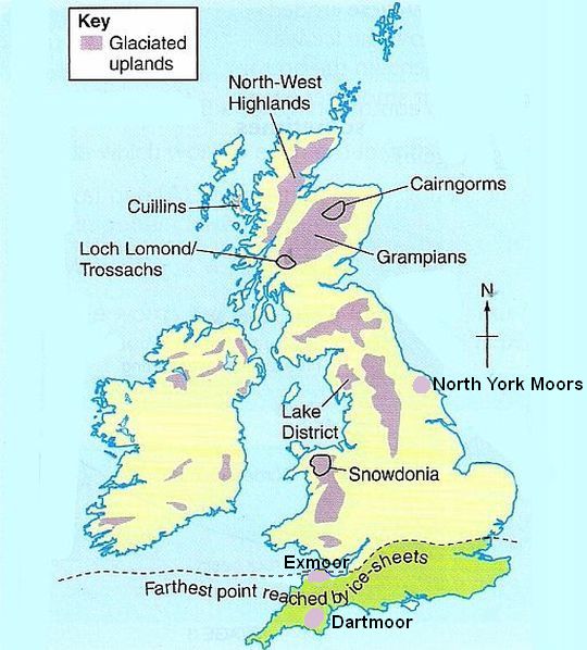
• Ice covered land as far as the Bristol Channel.
• Exmoor en Dartmoor zijn ook typische uplands. Ze zijn echter niet vergletsjerd geweest zoals de rest.
| . |
Hoofdstuk9
C. Two processes of glacial erosion (gletsjererosie):
1. plucking (=plukken).
2. abrasion (=schuren)
1. Plucking (=plukken)
Between a glacier and the rock underneath is a thin film of meltwater.
This water sometimes freezes, so the glacier becomes attached to the rock.
Then, when the glacier moves forward, it pulls away any loose pieces of rock.
This powerful process is called plucking.
(It is highly likely that the rock will already have loose fragments because of freeze-thaw weathering (vorstverwering). This is the weathering process
where water seeps
into
cracks (scheuren), freezes and expands,
gradually wedging open cracks
until the
rock breaks.)
2. Abrasion (=schuren)
Dit is het schuren van ijsmassa's (met het daarin reeds opgenomen gesteentepuin) over de onderliggende rotsbodem.
Once the glacier has plucked away pieces of rock, they become embedded (vast te zitten)
in
the bottom of the glacier and scrape (schuren) the
rock surface as the glacier moves.
This slower process of erosion is called abrasion (schuren).
Boek: ......... Warm aanbevolen voor wandelaars
die
regelmatig in
Groot-Brittannië Te bestellen bij: (Je kunt dit materiaal ook vinden op: |
Weet je aanvullingen en verbeteringen van deze tekst?
Graag een e-mail naar:
![]()
![]() ....
.... ![]() ....
....![]()
LAATST BIJGEWERKT : 29 -1-2021