| |
.
......... TOP.. TRAILS....SCHOTLAND
............ (mooiste langeafstandswandelpaden)
MIJN .CRITERIA VOOR TOP TRAILS:
Een langeafstandswandelpad (of groot gedeelte daarvan) is een top trail als
het door een aantrekkelijk landschap loopt. Dat spreekt voor zich.
Daarnaast zijn er nog twee technische criteria:
1. een goede markering in het terrein en
2. een goede kaart met daarin de routelijn.
Vooral het eerste punt, de markering in het terrein, moet goed zijn.
Je hoeft dan geen energie
te verspillen aan het vinden van de route.
( Als derde criterium zou je evt. ook nog een routebeschrijving kunnen noemen.
Je kunt het echter ook zonder, als de markering in het terrein en de kaart
maar in orde
zijn. )
In 2017 werd in een TV-uitzending de Britain's favourite walks Top 100
gekozen.
Het was de grootste verkiezing tot nu toe met meer dan 8000
deelnemers.
Schotland stond met 4 langeafstandspaden in de lijst:
- West Highland Way ( 14 e plaats),
- St. Cuthbert's Way (51e),
- Fife Coastal Path (62e) en
- Great Glen Way (64e)
West Highland Way scoort zéér hoog.
De andere 3 zijn
middenmoters.
• De deeltrajecten van de langeafstandspaden moeten nog in de kaart
worden aangegeven.
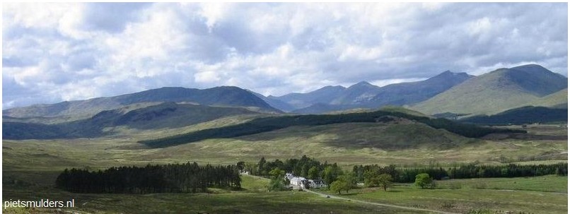
• West Highland Way.(Scottish Highlands)..
.. (Dramatic mountain scenery)
.. ( Mooiste deel: Tyndrum – Fort William = 68 km) ....
.. From Tyndrum, the West Highland Way winds through some of the
.. most spectacular scenery in Britain to the foot of Britain's highest
.. mountain, Ben Nevis.
.. The final stage of this spectacular trail crosses the Lairigmor pass to
.. Glen Nevis and the busy little town of Fort William, with glorious
.. views of Loch Leven, the pinnacled ridge of the Aonach Eagach and
.. the vast bulk of Ben Nevis.
.• St Cuthbert's Way (Scottish Borders) . (Historical trail )
....( Melrose – Holy Island (Lindisfarne) = 102 km)
....St Cuthbert's Way links a number of places associated with the story
... of a
7th century saint who travelled widely on foot through Scotland
... and northern England spreading the Gospel and performing healing
... miracles.
... Beginning at Melrose in the Scottish Borders where the saint started
... his ministry and ending at Holy Island in England where he ended his
... days, the trail passes through scenery of great variety and beauty.
.• Fife Coastal Path ( in voorbereiding )
... Enjoy an engaging hike through changing landscapes from Fife’s
... industrial south to the rural north.
... The Fife Coast Path explores an area of low cliffs and rocky bays,
... grasstufted dunes and picturesque fishing villages.
... Glimpse grey seals basking on the rocks just off the shore, and count
... the abundant reminders of Scotland’s rich history, including the caves
... with prehistoric paintings, the castles and the old watch houses, to
... name but a few.
... Between the many thriving little ports along the trail, the path
... explores a large part of Fife’s coastline, with plenty of beachside
... walking and scenic views over historic ruins to enjoy.
.• Great Glen Way
....The Great Glen Way National Trail follows the route of the Caledonian
.... Canal, which links the enormous lochs of the Great Glen all the way
.... from the Atlantic Ocean to the North Sea.
.... Open moorland, tree-lined towpaths, and towering, heather-clad hills
.... are staple views, alongside castles and forts that have witnessed
... some of the most bloody scenes of Scotland’s turbulent history.
.• Rob Roy Way . (Scottish Highlands) . (Historical Trail)
.... ( deeltraject: Callander – Pitlochry = 84 km)
.... Named after Scotland's most famous outlaw, the Rob Roy Way
.... meanders. across the Southern Highlands from Callander to Pitlochry
.... through many places where the outlaw was active.
.... Although the trail passes through some of the finest highland scenery,
.... it avoids the summits, keeping mainly to the glens,
.... following old tracks beside rivers and lochs and
.... over a few passes which provide wonderful views of the surrounding
.... mountains.
.• Speyside Way .(Scottish Highlands) . (Following a river valley)
... (deeltraject: Aberlour – Aviemore = 65 km + ... km voor de twee
... aanvullingen)
... The Speyside Way follows Scotland's loveliest river valley from
... Aberlour to
the foothills of the Cairngorm Mountains through the
... heart of. malt whisky
country.
... Following paths and disused railway trackbeds the trail passes
... through a beguiling mix of scenery: mixed woodland, heather-clad
... hills and ancient Caledonian pine forests. |
Mogelijk nog een 'top trail'- kandidaat ??
• Arran Coastal Way. (Stunning coastal scenery)
.... ( Meerdaags circuit vanuit Brodick (anticlockwise) = 100 km km)
.... The Arran Coastal Way combines coastal paths/ stretches of beach,
.... forest tracks, roads and hillpaths.to encircle this enchanting island.
.... Arran's rich and diverse wildlife is a special feature of the trail.
.... Seals are often seen basking on the shores of the island and the
.... coastline supports a wide variety of birds including eider, gannet,
.... cormorant, shelduck, oystercatcher, red-breasted merganser, redshank,
.... red-throated diver and fulmar. |
Wandelaars en grote grazers:
Er zijn jaarlijks incidenten tussen wandelaars en grote grazers
(runderen en paarden).
Let daarom goed op als je door een terrein loopt met grote grazers.
Zij zijn daar de baas en niet jij.
Doe als volgt:
1. Houd 50 m afstand, óók als dieren naar je toekomen.
2. Blijf de dieren aankijken. Keer ze dus niet de rug toe.
3. Lijn de hond aan. Loslopende honden veroorzaken onrust.
Vertrouw je het gedrag van een of meerdere dieren niet, maak dan
rechtsomkeer
en zoek m.b.v. je kaart een andere route.
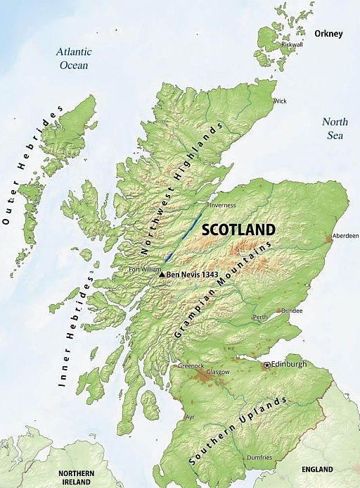
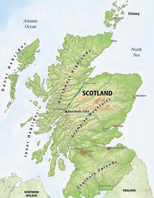
Geography:
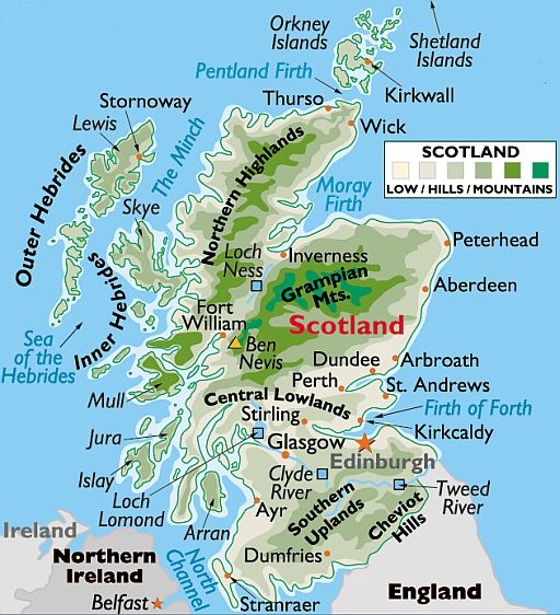
The rough and tumble landscape of Scotland was once covered by
glaciers during the Pleistocene Ice Age.
When those masses of ice melted they left in their wake a rocky,
pockmarked landscape of mountains and rolling hills, dozens of deep
lakes, rivers and streams.
From a geological perspective the country has three main sub-divisions:
1. Highlands and islands:
..... 1a. Northwest Highlands are generally mountainous with many lofty
.......... peaks.
..... 1b. Grampian Mountains extend southwest to northeast, and include
........... Scotland's (and the UK's) highest point, Ben Nevis , at 1,344 m.
..... 1c. Islands. Nearly 800. Most are hilly and rugged.
............ The major groups include the Inner and Outer Hebrides , Orkney
............ and Shetland.
2. Midland Valley ( or Central Belt or Central Lowlands) a rift valley,
formed by ancient
volcanic eruptions, is a relatively flat area punctuated
by hills
(the East Coast Belt has been included with the Central Belt).
3. Southern Uplands is a hilly area with wide, green valleys,
fronted in the south by the Cheviot Hills on the border with England.
There are numerous bodies of inland freshwater including
Loch Lomond and Loch Ness. The Tweed and Clyde are the largest rivers. |
Boeken:
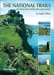
 THE NATIONAL TRAILS THE NATIONAL TRAILS
.... The 19 National Trails of
England, Scotland
.... and Wales,
Paddy Dillon
.... (Cicerone Guide)
|
.
.
|
|
Weet je aanvullingen en verbeteringen van deze tekst?
Graag een e-mail naar:

 .... ....  ... . ... .
LAATST BIJGEWERKT : 7-1-2019
|
|