...
...............NORTH . EAST . ENGLAND
| .BRITAIN'S FAVOURITE WALKS TOP 100 ― NORTH...EAST...ENGLAND |
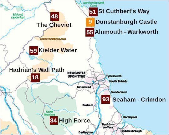
• Klik je op nummer 48 in de kaart, dan word je doorverbonden met kader 48 hieronder.
• 48 betekent: de wandeling stond op de 48ste plaats in Britain's Favourite Wal...
• Dunstanburgh Castle, de wandeling uit de Top 10, heeft een oranje nummer.
• Lichtbruin = National Park
• Lichtgroen = AONB (Area of Outstanding Natural Beauty) (the next step down from a National Park).
• In Noordoost-Engeland heb je één belangrijk National Park: Northumberland National Park. Het ligt tussen Hadrian's Wall en de Schotse grens.
• Van de North Pennines ANOB behoort alleen het oostelijke deel tot North East England.
| aaaa |
9
9. Ruined Castle Dunstanburgh
. ..... .Northumberland Co...
........ 5 km ...... licht
streetmap.co.uk
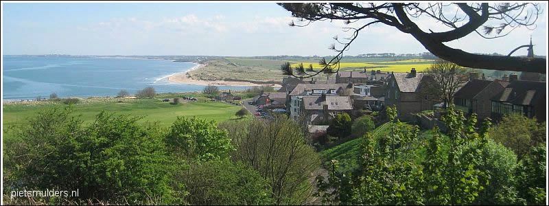
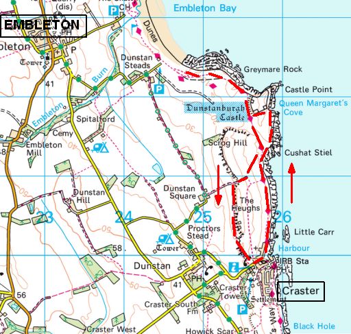
This short walk on the rugged Northumberland coast starts in the fishing village of Craster and leads along a wildlife-rich seafront to mighty ruined castle Dunstanburgh
It is an archetypal medieval castle. It was built in 1313 and stands on a remote headland (=kaap) on a wave-battered coastline, with its great twin-towered keep still clearly visible despite much of the fortress now being in disrepair.
This is a great walk all year round, with
- blooming flowers in spring,
- rock pools to explore in summer,
- migrating birds in autumn and
- quiet paths in winter.

• ruined castle Dunstanburgh, perched on a promontory (vooruitspringende rots)...formed by a black basalt outcrop (ontsluiting), known as the Whin Sill.
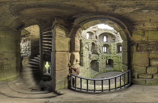
• Inside the ruins.
Start / finish: Craster:
Low Newton car park, 1 Coastguard Cottages, Alnwick NE66 3EH
ANWB Campings:
Zie voor een overzicht anwb.nl/engeland
Wildkamperen (bivak):
Gaf mij geen problemen.
Zie voor een goede introductie van de verschillende kustvormen:
engeland_coastal-landscapes
Verdere info:
www.pietsmulders.nl/e...
........................................
www.nationaltrust.org...
.......................................
https://osmaps.ordnan...
The Outdoor Guide verdict (=oordeel):
Short and spectacular, this is perhaps Britain’s ultimate coastal walking route with a pretty fishing port, mighty castle, spectacular wildlife and wonderful sea views to enjoy.
.... Wandelgids: Rother Wandelgids 'Noord-Engeland' .............. Kaarten: OS Explorer 332 en 340 Deze heb je nodig als je van Beadnell naar Craster loopt. Voor de korte wandeling van Craster naar de kasteelruïne voldoet bovenstaande kaartfragment. Te bestellen bij: Reisboekwinkel de Zwerver (webshop voor reisgidsen en landkaarten) ... |
| aaaa |
18
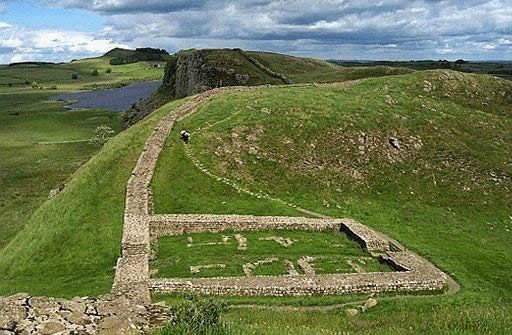
18. Housesteads ― Steel Rigg,
............. (Hadrian’s Wall)
............ Northumberland N.P. .10½ km .licht
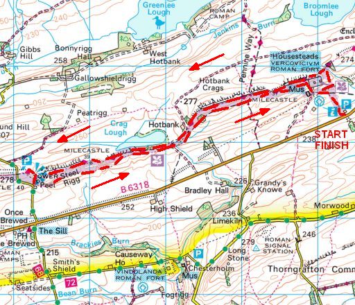
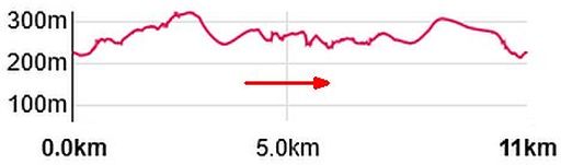
Totale stijging = 430 m
This short circular walk explores the most dramatic section of Hadrian’s Wall, an 84-mile route that was once the northern frontier of the mighty Roman Empire.
You’ll find history every step of the way if you walk the entire Hadrian’s Wall National Trail from the Cumbrian coast to Newcastle, passing the remains of Roman settlements and forts and tiptoeing along sections of the legendary wall that still stand to this day.
But if you don’t fancy the whole Hadrian’s Wall path, this 7-mile circular route near the town of Haltwhistle in Northumberland covers arguably its most dramatic section.
Starting at Housesteads Visitor Centre and crossing Hotbank Crags on the way to Steel Rigg, you’ll pass historical landmarks and dramatic natural features including one of Britain’s most photographed trees at Sycamore Gap (one for the Robin Hood Prince of Thieves fans out there!).
You’ll return on the Roman Military Way, and go home with your head
full of history and tales to tell your friends.
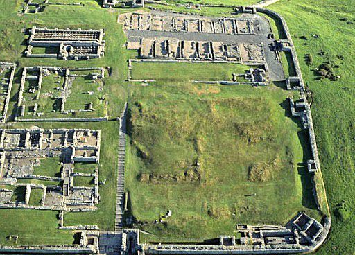
• Housesteads Fort from the air, looking north.
• Het was één van de 17 grote Castella (forten) die langs de muur werden opgericht.
• Op de foto zie je de rechtse (= oostelijke) helft van het fort.
• Rechtsboven aan de rand van de foto is nog een klein stukje van de
Muur zichtbaar.
• Hadrian's Wall and Milecastle 39 (Versterkte poort).
• Peel Crags provide a great view of the
Milecastle and to Crag Lough (looking eastwards).
• The Milecastle is situated in one of the drops of the hillside.
Start / Finish:
Car park at the Housesteads Visitor Center.
ANWB Campings:
Zie voor een overzicht anwb.nl/engeland
Wildkamperen (bivak):
Gaf mij geen problemen.
Verdere info:
www.pietsmulders.n...
....................................
Mooie video, waar me...
.....................................
https://en.wikipedia....
....................................
https://osmaps.ordnan...
The Outdoor Guide verdict (=oordeel):
This bitesize section of the Hadrian’s Wall National Trail crosses some
of England’s most dramatic and historical landscapes in just a few
short miles.
... Wandelgids: Tocht 19 ... Langs Hadrians Wall Kaart: Te bestellen bij: Reisboekwinkel de Zwerver (webshop voor reisgidsen en landkaarten) .... |
| aaaa |
34
34. High Force and Low Force
............ (Upper Teesdale)
...........North Pennines AONB.
........... 14 km... lichte wandeling
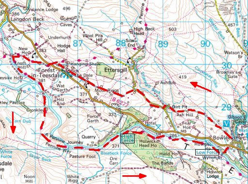
streetmap.co.uk
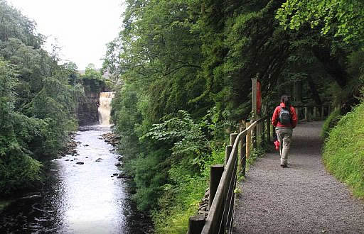
This circular walk through the heart of the Durham Dales visits High Force – one of the most spectacular waterfalls in England.
Surrounded by the beautiful landscape of Upper Teesdale, High Force is a genuine force of nature, cascading more than 20 m into the plunge pool (=stortbekken?) beneath it.
Your route leads through pretty woodlands on the legendary Pennine Way long distance trail.
The falls aren’t the only highlights on this walk, however.
You’ll also
pass through:
- the North Pennies AONB (Area of Outstanding Natural
Beauty) and
- the Moor House-Upper Teesdale NNR (National Nature
Reserve),
home to
some of the UK’s rarest plants and most iconic upland birds – everything
from wildflowers and ferns to roe deer and rabbits.
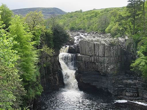
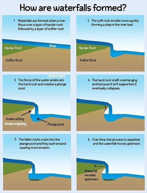
• The Whin Sill is responsible for one of Britain’s most famous waterfalls: High Force. Here the River Tees falls more than 20 m over the resistant rocks of the Whin Sill.
• Two types of rock can be seen at the falls.
1. The lower rocks are horizontal sediment layers.
2. The upper rocks are dark dolerite and has vertical joints. They are much harder than the sediment layers underneath.
• This tough dolerite is resistant to erosion, which explains the location of the waterfall.
Where there is no dolerite, the valley broadens out and waterfalls are absent, but other bands of dolerite create waterfalls just a short distance upstream at .Cauldron Snout and downstream at Low Force.
Start / finish:
High Force waterfall carpark, Barnard Castle, Forest in Teesdale,
Barnard Castle DL12 0XH
ANWBCampings:
Zie voor een overzicht anwb.nl/engeland
Wildkamperen (bivak):
Gaf mij geen problemen.
Verdere info:
www.world-of-waterfa ...
(heeft ook een fotogalerij en aantal video's)
https://en.wikipedia.o...
........................................
https://osmaps.ordnances...
The Outdoor Guide verdict (=oordeel):
Two spectacular waterfalls for the price of one on a beautiful
woodland loop that follows a popular section of the Pennine Way.
.... Wandelgids: ................... Kaart: OS Explorer OL31 Te bestellen bij: |
| aaaa |
48
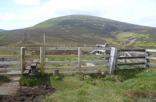
48. The Cheviot (816 m)
..........Northumberland N.P.
.......... 15 km .. mountain ... zwaar
Challenging: steep ascents and very exposed on peaks (but there are also lots of easier routes to enjoy the hills).
The Cheviot is the highest point in Northumberland.
You can start at Harthope Valley and take in the two main summits: Cold Hill and Cairn hill.
It's a strenuous but rewarding walk over the long trail of hills straddling
the England-Scotland border, with steep ascents/descents and bogs,
but
there are also lots of easier routes to enjoy the hills.
Cheviot Hills — In northern England, close to the Scottish Southern Uplands, the Cheviot Hills are composed of a great thickness of hard, ancient lavas and intrusions of igneous rocks, covered by a thick layer of peat. Peat — A thickness of partially decayed vegetation, formed in wet anaerobic ground. |
Noord-Engeland (Rother Wandelgids) heeft ook een wandeling
naar de top van
de Cheviot.
Daar start men echter in het gehucht Cocklawfoot, een aantal
kilometers ten westen van de top.
• Looking towards the Cheviot from Scald Hill.ll.
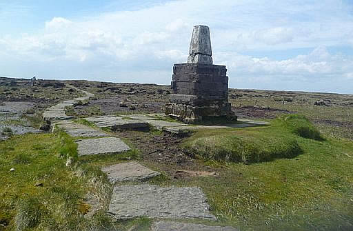
• The summit of the Cheviot is marked by a triangulation pillar.
• In order to prevent erosion to a sensitive landscape, a millstone slabbed pathway has been laid running, almost without interruption, across the summit plateau.
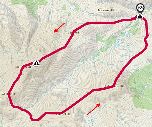
 Totale stijging = 880 m
Start / finish:
Harthope Valley.
ANWB Campings:
Zie voor een overzicht anwb.nl/engeland
Wildkamperen (bivak):
Gaf mij geen problemen.
Zie voor en goede introductie van de uplands:
uplands
Verdere info:
https://en.wikipedia.o...
.......................................
https://osmaps.ordnance...
Wandelgids: Kaart: Te bestellen bij: |
| aaaa |
51
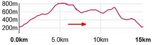
51. .St Cuthbert's Way
........... .langeafstandspad
.......... ..licht/middelzwaar
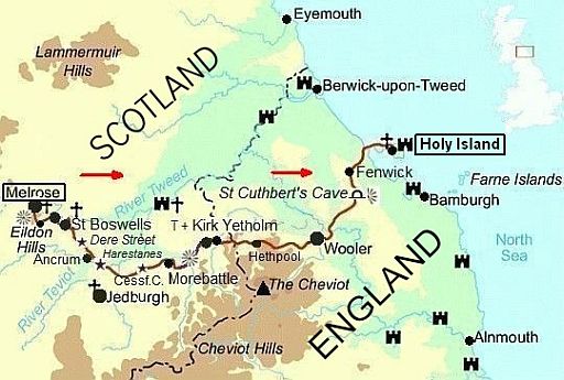
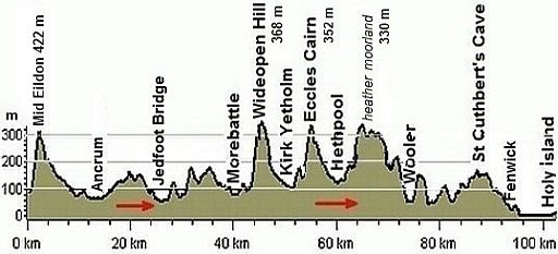
This walk is worth it for the finish along Lindisfarne Causeway alone –
surely the finest end to any of Britain’s long-distance trails.
This 100 km walk follows St Cuthbert’s Way pilgrim trail through beautiful and varied countryside from Melrose in the Scottish Borders to Holy Island off the Northumberland coast.
Crossing the Anglo-Scottish border twice and passing through the northern foothills of the Cheviots, this route is inspired by the religious life of St Cuthbert, which began in Melrose in 650AD and ended in his final resting place on Holy Island.
You’ll pass through a remote and ever-changing landscape with huge
views across ancient borderlands.
A sense of history and culture swirls around you all the way to the route’s spectacular finish on the mile-long Lindisfarne Causeway, which is only
exposed at low tide (research and plan this section carefully).
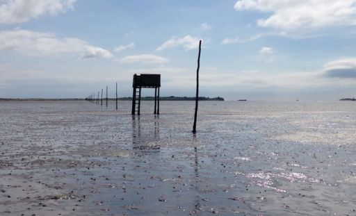
• During low tide there are two routes onto the island:
1.
barefoot across the sands (de drooggevallen wadzanden) on the Pilgrim's Way, marked by a line of barnacle-encrusted
poles.
2. over the tidal causeway (=getijdendam).(Desgewenst lift je met
een van de auto's over de drooggevallen dam naar het eiland)
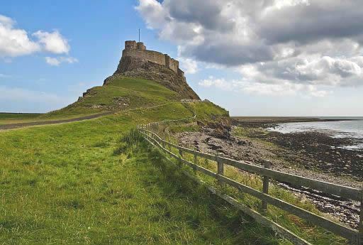
• Lindisfarne Castle is perched on a small hilltop, a dolerite outcrop (ontsluiting).
This hilltop is a
dyke (=gang), a wall-like body of intrusive igneous rock, formed as magma pushes up towards the surface through cracks in the
rock
and harden there.
Mooie dagetappes: Kirk Yetholm ― Holy Island
1. Kirk Yetholm ― Wooler
.. 21 km ..Middelzwaar . ↑ 620 m
2. Wooler ― Fenwick
....19 km .. Middelzwaar .. ↑390 m
... (Transfer to Lowick 5½ km by road)
3. Fenwick ― Holy Island
... 10 km.. Licht .... ↑0 m
ANWB Campings:
Zie voor een overzicht anwb.nl/engeland
Wildkamperen (bivak):
Gaf mij geen problemen.
Verdere info:
www.pietsmulders.nl/sch...
............................................
https://osmaps.ordnancesu...
Wandelgids: ..................... Kaart: OS Explorer 340 Te bestellen bij: |
| aaaa |
55
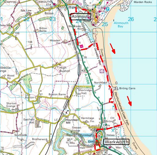
55. Alnmouth ― Warkworth
.......... Northumberland Co.
..........10½ km .....licht
Take a walk along the coastline, starting in the village of Alnmouth. and ending with the phenomenal Warkworth Castle.
The bay has miles of golden sand and is located on the mouth of the River Aln.
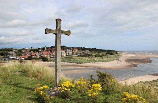
• The village Alnmouth seen from across the River Aln from Church Hill.
• Alnmouth with its beautiful beach and rich history, makes for a pleasant stop on the coastal walk, but the wide and fast-flowing River Aln entails a diversion inland.
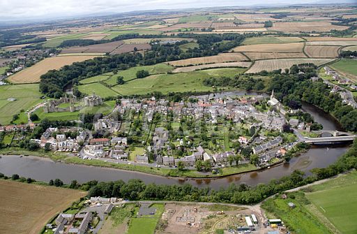
• Het dorp Warkworth ligt in een langwerpige lus van de rivier Coquet.
• Warkworth is best known for its well-preserved medieval castle, church and hermitage.
streetmap.co.uk
Start: Alnmouth.
Finish: Warkworth.
There is a coastal bus
ANWB Campings:
Zie voor een overzicht anwb.nl/engeland
Wildkamperen (bivak):
Gaf mij geen problemen.
Zie voor een goede introductie van de verschillende kustvormen:
engeland_coastal-landscapes
Verdere info:
www.pietsmulders.nl/eng...
............................................
https://osmaps.ordnancesu...
Wandelgids: Kaart: Te bestellen bij: |
.
| aaaa |
59
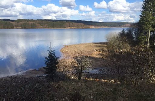
59. Kielder Water and Forest Park
..........Northumberland National Park
........... 29 km.... licht (maar wel lang)
The biggest man made lake (Reservoir) in Northern Europe with
a
variety
of
wildlife
and vast ‘working’ woodlands.
This beautiful place
has
recently become a designated Dark Sky Park.
Sculptures are scattered along 27 miles of forest trail.
Most easy going, much of it cycle routes so level and accessible.
This is the full circuit of the Water – shorter sections can be done too.
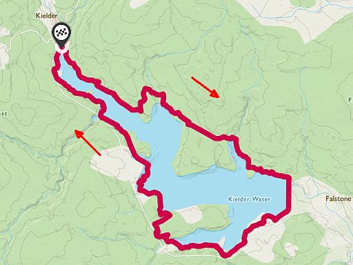
Start / finish: Kielder.
ANWB Campings:
Zie voor een overzicht anwb.nl/engeland
Wildkamperen (bivak):
Gaf mij geen problemen.
Zie voor en goede introductie van de uplands:
uplands
Verdere info:
https://en.wikipedia.org/...
...........................................
https://osmaps.ordnances...
Wandelgids: Kaart: Te bestellen bij: |
| aaaa |
93
93. Seaham―Crimdon
......... (Durham Heritage Coast Path)
........Durham Heritage Coast
........ 18 km ....lichte wandeling
Durham Coastal Path
Walk along this 18 km England Coast Path National Trail crossing
cliff-tops, meadows, wooded gorges, coastal denes and magnesian
limestone coastal grasslands to meet a vast array of wildlife and
uncover the rich heritage of
the area.
Generally easy going – only challenge is distance.
The England Coastal path gives loads of choices.
You can make it longer or shorter easily.
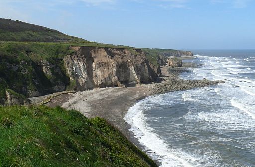
• Coastline approaching Easington Colliery.
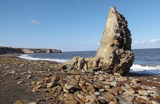
• Sea stack (=brandingspilaar) on Blast Beach.
• Further to the north are the sea cliffs at Nose's Point.
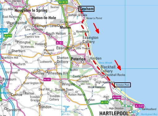
streetmap.co.uk
Zie voor een goede introductie van de verschillende kustvormen:
engeland_coastal-lands...
Start: Seaham.
Finish: Crimdon.
There is a coastal bus.
ANWB Campings:
Zie voor een overzicht anwb.nl/engeland
Wildkamperen (bivak):
Gaf mij geen problemen.
Zie voor een goede introductie van de verschillende kustvormen:
engeland_coastal-landscapes
Verdere info:
www.durhamheritagecoas...
...................................................
https://osmaps.ordnancesu...ces
Wandelgids: Kaart: Te bestellen bij: |
| aaaa |
..Deze wandelsite is niet-commercieel, onafhankelijk en gratis. Dat is enkel mogelijk door steun van de bezoekers. Uiteraard kun je ook doneren door overschrijving op mijn |
Weet je aanvullingen en verbeteringen van deze tekst?
Graag een e-mail naar:
![]()
![]() ....
.... ![]() ...
... ![]()
LAATST BIJGEWERKT : 7-1-2019