...
..................EAST . OF . ENGLAND
| ..BRITAIN'S. FAVOURITE. WALKS. TOP 100.―.EAST of .ENGLAND |
• 84 betekent: de wandeling eindigde op de 84ste plaats in Britain's.Favourite
• Klik je op dit nummer 84 in de kaart, dan word je doorverbonden met kader 84 hieronder.
• Lichtbruin = The Broads National Park........
• Lichtgroen = AONB (Area of Out.... :
(the next step down from a National Park)
1. Norfolk Coast AONB
2. Suffolk Coast and Heaths AONB
3. Dedham Vale AONB.
| aaaa |
42
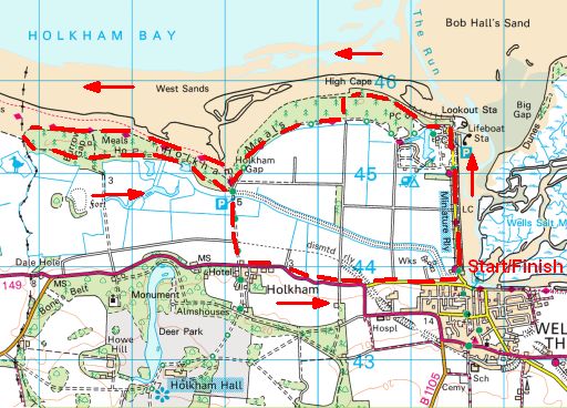
42. Wells-next-the-Sea
..........Norfolk Coast AONB.. 13 ½ km .licht
Start and finish in the attractive seaside town of Wells-Next-the-Sea. This walk takes in a bustling harbour, golden sand dunes and thick pine woodlands.
Wells beach is famous for its beach huts (strandhuisjes) , but
it’s the sand dunes that your
dog will be desperate to explore.
And if you have enough energy left when
you leave the beach, it’s well
worth strolling through the stunning pinewoods to make this into a
circular route.
To extend the walk continue west along the beach to Holkham Gap.
Although this is a simple route, don’t underestimate the length of the
sea wall (zeedijk) (which you have to walk in both directions) and that the whole walk covers
13 ½ km.
The terrain is flat and mostly easy underfoot, but prams and wheelchairs
will struggle on the beach and on the rough paths through the pinewoods.
• Standing on the sea wall (zeedijk) and looking to Wells-next-the-Sea.
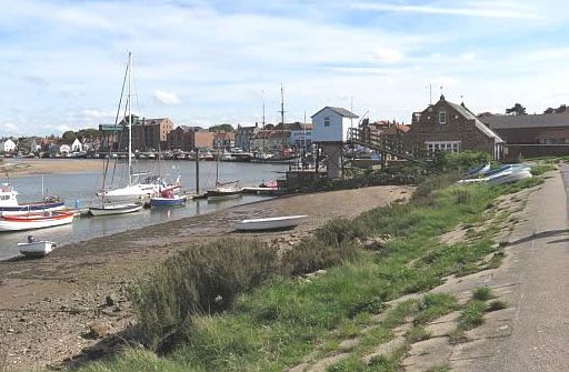
• Although coasters no longer call at the quay and the fishing fleet is reduced in size, Wells still has a bustling quayside and the harbour continues to provide shelter for fishing yachts. It only remains open because of repeated dredging (uitbaggeren).
• This is one of these small harbours, which are 'sea' at high tide (hoogwater) and tidal flat (=wad) at low tide.
• The town is now a mile from the open water. (Wells-on-Sea is verleden tijd, het is nu geworden Wells-next-the-Sea.)
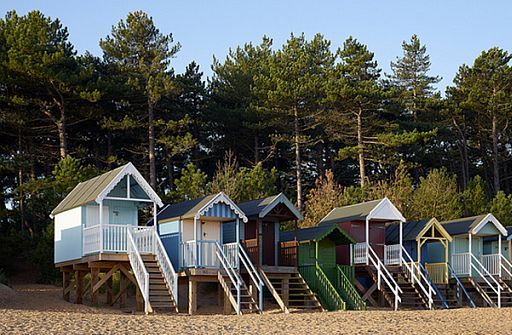
• A row of colourful beach huts (strandhuisjes) in front of the shelter-belt of Corsican
pines. These pines were planted in the 1860s to protect the newly reclaimed farmland from windblown sand.
• The beach huts are on stilts to protect themselves against flooding.
 streetmap.co.uk
Start/finish: Wells-next-the-Sea. (Stearmans Yard car park)
Zie voor een goede introductie van de verschillende kustvormen:
engeland_coastal-lands...
ANWB Campings:
Zie voor een overzicht anwb.nl/engeland
Wildkamperen (bivak):
Gaf mij geen problemen.
Verdere info:
www.pietsmulders.nl/en...
...............................................
https://osmaps.ordnancesu....
Wandelgids: .......... Tour 31 Kaart: ................... Te bestellen bij: Reisboekwinkel de Zwerver (webshop voor reisgidsen en landkaarten) |
| aaaa |
68
68. Blakeney Point
..... Norfolk Coast AONB.... 12 km ..licht
.....(volgens National Trust middelzwaar!)
This coastal walk is a fantastic one for wildlife fans.
It takes in a beautiful sand and shingle spit (kiezel-schoorwal) which
during breeding
season is a playground for a colony of 500 seals.
Blakeney Point is part of the Blakeney National Nature Reserve and has been managed by the National Trust since the early 1900s.
The area is well known for its thriving seal colonies, with grey seal pups born from November to January.
Seal mating season takes place shortly after the pups are born with bulls fighting for territories and female attention, which creates an awesome spectacle.
As well as seals, Blakeney Point is also an internationally important breeding ground for seabirds with up to 4,000 Sandwich terns breeding here from
March to August.
The route will really depend on the tide conditions. Ideally you need to reach Blakeney Point at low tide.
This walk starts from the car park at Cley beach and follows the beach and shingle spit, home to rare plants including sea poppy, sea pea and shrubby sea blight.
Keep walking until you reach the dunes at the end of the spit then turn left over the main ridge (away from the sea) to reach the National Trust’s impressive blue Lifeboat House.
A wooden boardwalk leads from the Lifeboat House to the beach by Blakeney Harbour, which is a great place for spotting seals on the tidal sands.
Explore the beach, dunes and spectacular wildlife, then return via your outbound route to Cley car park.
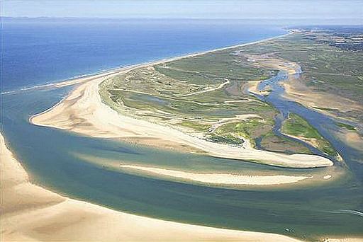
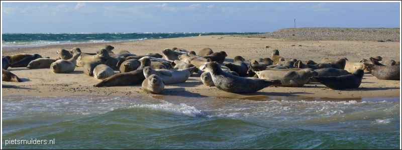
• Blakeney Point, the sand spit (schoorwal) which has the largest seal colony in England.
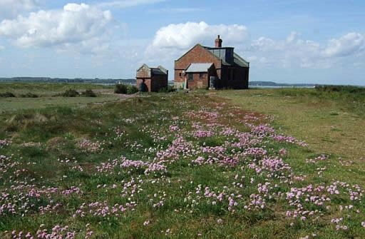
• Blakeney Point, the Watch House.
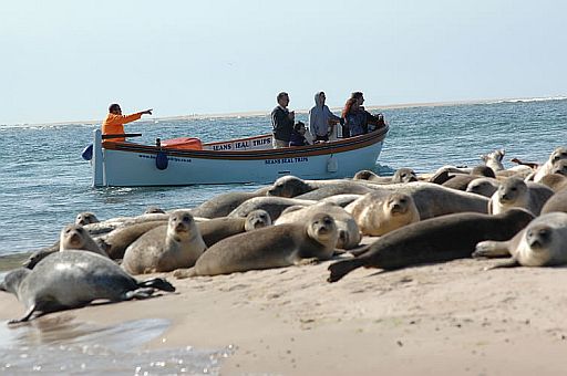
• The seals bask at high tide (hoogwater) on the sand-bars and are viewed from the boats.
• They are a mixture of
Common seals (Gewone zeehond) and Grey seals (Grijze zeehond).
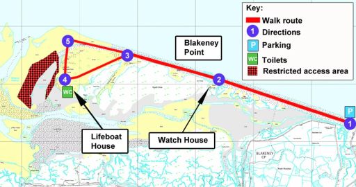
Start/finish: Cley beach, Norfolk Wildlife Trust car park.
Zie voor een goede introductie van de verschillende kustvormen:engeland_coastal-lands...
ANWB Campings:
Zie voor een overzicht anwb.nl/engeland
Wildkamperen (bivak):
Gaf mij geen problemen.
Verdere info:
www.nationaltrust.org.u...
.............................................
www.pietsmulders.nl/e...
.............................................
https://osmaps.ordnance...
Wandelgids: Kaart: ................. Te bestellen bij: Reisboekwinkel de Zwerver (webshop voor reisgidsen en landkaarten) |
| aaaa |
71
71. Norfolk Coast Path
..........lichte wandelingen
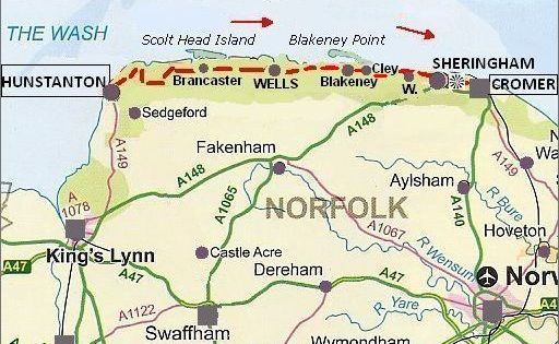
The Norfolk Coast Path is a stunning long-distance trail that showcases the golden beaches, pretty villages and glorious wildlife of the East Anglian coast.
The entire route stretches for 138 km from Hunstanton to
Hopton-on-Sea, through a landscape taking in everything from busy
seaside towns and tidal marshes to sweeping sand dunes and huge
skies
that seem to stretch beyond the horizon.
Highlights of the Norfolk Coast Path include:
- Hunstanton Cliffs;
- the RSPB nature reserve at Titchwell;
- Brancaster Staithe, Burnham Deepdale and Burnham Overy Staithe;
- the vast sandy expanse of Holkham Beach;
- the pinewoods, beach huts and quirky shops of Wells-Next-The-Sea;
- the seal colonies at Blakeney Point;
- and much, much more.
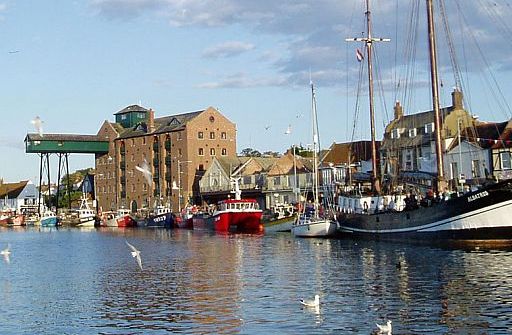
• The beautiful seaside town of Wells-next-the-Sea, comprised of stately Georgian houses and a small harbour.
• On the left is the famous landmark (=markant object), a large green-painted granary (graanpakhuis) with loading gantry, which was built around 1905.
• This granary has now been turned into luxury flats.
• The town once boasted over a dozen granaries and maltings (mouterijen) , but today only this one is left.
• The quay is still used by some fishing boats that you can see unloading their catch.
Zie voor een goede introductie van de verschillende kustvormen:
engeland_coastal-lands...
ANWB Campings:
Zie voor een overzicht anwb.nl/engeland
Wildkamperen (bivak):
Gaf mij geen problemen.
Verdere info:
www.contours.co.uk/n...
.........................................
www.pietsmulders.nl/...
........................................
https://osmaps.ordna....
Rother Wanderführer 'England Ost',
Sabine Gilcher,
Bergverlag Rother
heeft hier 4 Touren, waarvan 2 Top-Touren:
29. Kelling Heath und Sheringham Park
.... Topper .. 4 uur
30. Cley und Salthouse Marshes .. 2.15 uur
31. Brancaster Staithe – Holkham Beach
.... Topper.. 5 uur
32. Küste bei Hunstanton .. 2.45 uur.
Travel to Wells-next-the-Sea and book there your accommodation.
There is a coastal bus.
Wandelgids: Kaart: ............. Te bestellen bij: Reisboekwinkel de Zwerver ( webshop voor reisgidsen en landkaarten) |
| aaaa |
77
77. Flatford and Constable Country
......... walking trail
......... Dedham Vale AONB . 11 ½ km.. licht
It’s easy to understand why Constable loved this lovely lowland landscape, and this walk takes in its most treasured highlights.
This walk on the Essex-Suffolk border explores the picturesque Stour Valley and Dedham Vale, made famous by John Constable’s 18th century paintings.
Constable was one of 18th century England’s most celebrated
landscape artists, and having been born in Suffolk he’s most well known
for his paintings of Dedham Vale and its surrounding areas.
And it’s not hard to
see why.
This beautiful lowland England landscape is full of picturesque villages, rolling farmland, lazy rivers, grassy meadows and ancient woodlands;
all of which are perfect for exploring on foot.
With much of East Anglia’s landscape drained and ploughed, the
wildlife-rich hedgerows and wildflower meadows of this AONB (Area of outstanding Natural Beauty) provide a green oasis among busy arable faming countryside.
The walking route is a ramble from Manningtree through the quintessential
English vistas of Flatford.
The mostly flat walk follows a section of the Stour Valley, past the hamlet of Flatford and Flatford Mill, with its National Trust café.
You’ll also pass through the lovely village of Dedham, where you can visit museums, art galleries, pubs, shops, and even hire rowing boats and canoes.
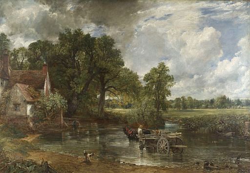
• John Constable, The Hay Wain. Vergelijk met de volgende foto (de huidige toestand):
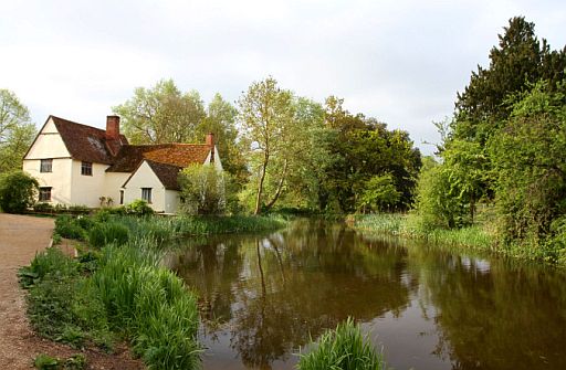
• Willy Lott's Cottage.

• Flatford Mill
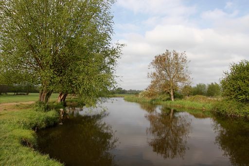
• Stour River Valley.
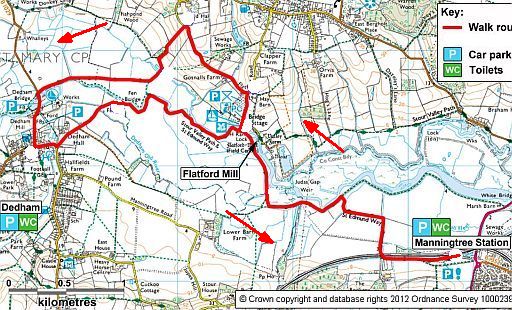
Start/finish: Carpark Manningtree Station.
ANWB Campings:
Zie voor een overzicht anwb.nl/engeland
Wildkamperen (bivak):
Gaf mij geen problemen.
Verdere info:
www.nationaltrust.org.uk/....
..................................................
https://osmaps.ordnancesur...
Wandelgids: .......... Kaart: OS Landranger 168 Te bestellen bij: Reisboekwinkel de Zwerver ( webshop voor reisgidsen en landkaarten) |
| aaaa |
84
84. Cambridge City Walk
......... (Colleges and the Backs)
......... Cambridge. 7 ½ km .. licht
Cambridge is an ancient, quintessentially English city with outstanding medieval architecture, a lovely riverside setting and attractive inner-city greens.
This walk takes in all of Cambridge’s most famous landmarks, including:
- King’s College and Trinity College, which lists Isaac Newton among its famous alumni, and
- the glorious riverside walk along the ‘Backs’ that shows off the quieter side of colleges that have housed and helped form some of Britain’s greatest academic minds.
But this walk isn’t just about the colleges. You’ll also cross the large grassy common of Parker’s Piece (widely acknowledged as the
birthplace of association football), stroll past the doors of the Scott-Polar Research Inst.
(worth a visit for anyone fascinated by Arctic and Antarctic exploration), and walk stretches of the beautiful River Cam that will be crammed
with punters even in the dead of winter (have a go, we dare you).
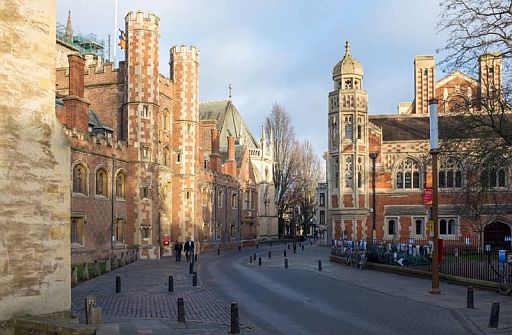
• St. John’s Street with St. John’s College on the left.
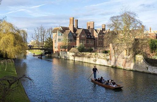
• The Backs.
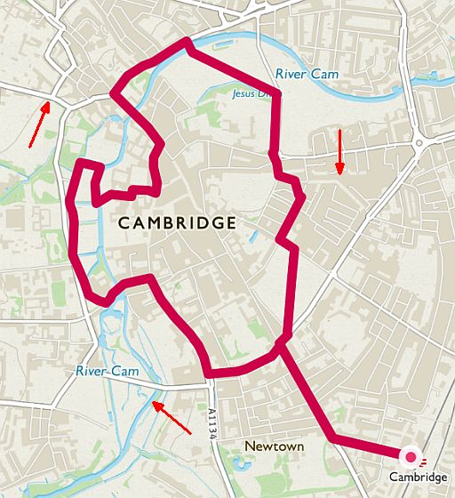
Start/finish: Cambridge Station.
Map: OS Explorer 225, 229
ANWB Campings:
Zie voor een overzicht anwb.nl/engeland
Wildkamperen (bivak):
Gaf mij geen problemen.
Verdere info:
www.theguardian.com/tra...
..................................................
https://osmaps.ordnancesur....
Wandelgids: Kaart: Te bestellen bij: Reisboekwinkel de Zwerver (webshop voor reisgidsen en landkaarten) |
| aaaa |
..Deze wandelsite is niet-commercieel, onafhankelijk en gratis. Dat is enkel mogelijk door steun van de bezoekers. Uiteraard kun je ook doneren door overschrijving op mijn |
Weet je aanvullingen en verbeteringen van deze tekst?
Graag een e-mail naar:
![]()
..![]() ....
.... ![]() ...
... ![]()
LAATST BIJGEWERKT : 7-1-2019